Paddlers: Hugh, Geoff plus Steve W, Gavin and Sean
Weather: Dry and bright; occasional sun, wind F2. Occasional squall F4 with hail
Report: Part 1 of the day was the outdoor safety test; the conclusion of Sea Kayak Expedition Training. The first exercise involved rescue of an upturned paddler and was accomplished with some expertise in extremely cold water (<8 degrees).
Gavin rescues SteveGavin “Pumps Out” after rescue by Sean
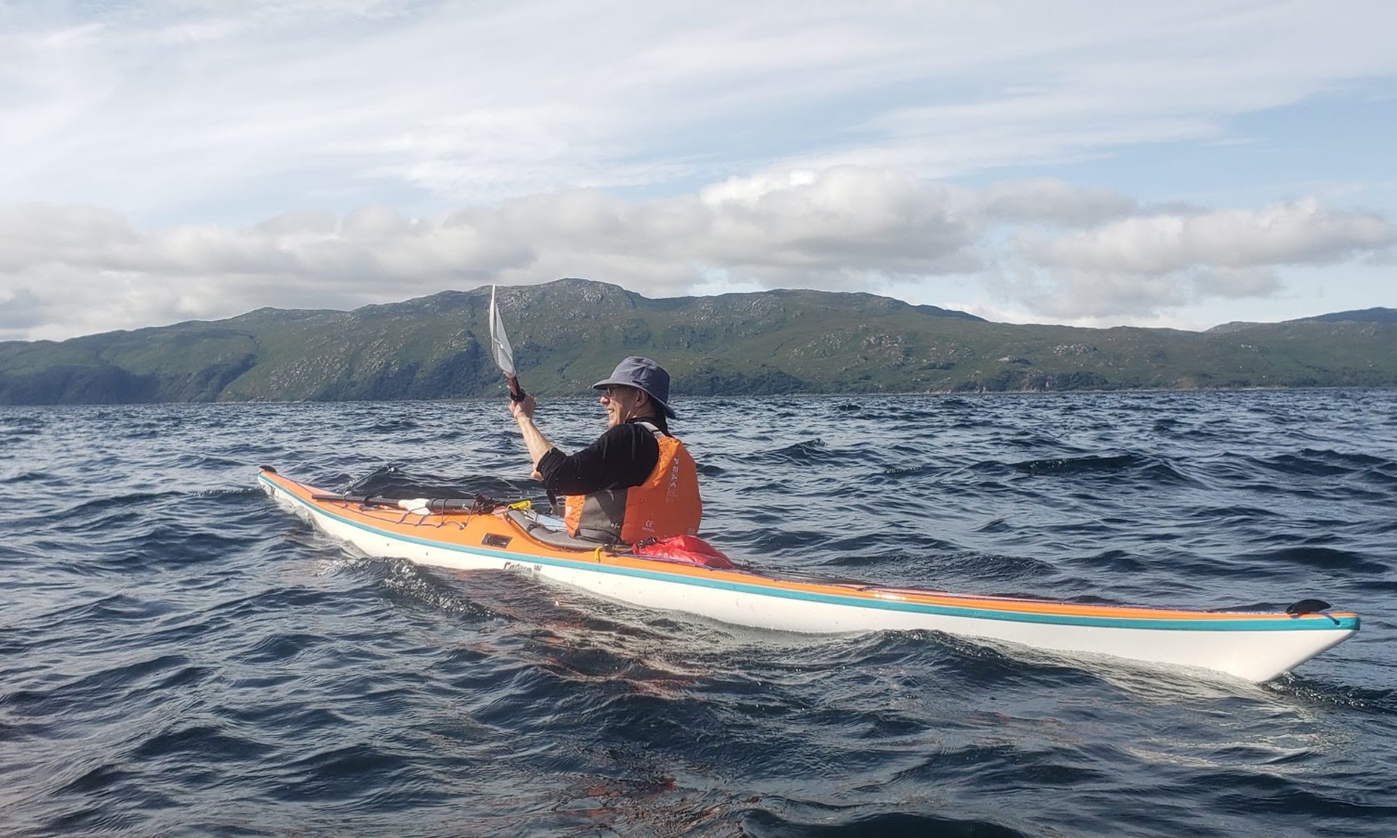
The second task was a solo rescue using a paddle float, the most reliable method. Again a success, albeit after a few capsizes as the body twisted into the seat.
Steve does his solo rescueSean attempts his solo
The third task involved getting warm, lunching and preparing and ready for the Trip
The Trip Part 2 of the day involves a longish journey to ensure that the paddler would have the stamina to reach safety if conditions degenerated suddenly. The chosen target was the sugar boat.
Inspecting the MV CaptayannisHeading west for Rosneath Point
The trip out of some 8km was something of a slog for all of us. Nobody wanted to try their hand at climbing on the sugar boat and after a rather cursory visit we were off heading for Rosneath Point and Green Island.
Looking East with Ardmore and the Sugar Boat in the distance
We landed at the good beach at the Green Island signalling/degaussing station for a coffee, stretch and chance to relax in the sun.
After the 15 minute break we headed off across the bay towards the mouth of the Gareloch. On the rocky promontory were a colony of seals but in the north-east could be seen some pretty rough weather which hit us just a few minutes after departure. The wind rose to a strong F4 and the shallow nature of the bay induced a sizeable swell that Gavin and Sean were completely unfamiliar with. Unable to turn Sean was toppled into the sea and Gavin ran for the beach. Although the rescue was achieved without problem the accompanying heavy hail was less than pleasant. With Gavin relaunched, Sean’s boat pumped out and suitable head-wear found, we were off on an uneventful 4km trip back to our start place at the RNCYC.
As ever it was a good trip with the additional benefit that it taught the Beginners a great deal and showed to all of us why we carry out this safety training. As some of us had previously experienced on Loch Etive the weather can change from calm and pleasant to maelstrom in a matter of minutes.
Weather: Lovely and unseasonably warm until clouds covered sun and southerly wind got up
Route: Glen Mallon-Carrick-Mark_Glen Mallon
Report: Another hastily arranged trip to make use of a gap in the weather. Surprised to find both car parks at Finnart full to overflowing so rather than try to push through the hordes of scuba divers we headed further north to the slip at Glen Mallon (just south of the jetty). This was empty and proved an excellent choice. The disadvantages of having to unload and walk across the road (and beach at low tide) was more than balanced by the benefit of not clambering down a broken wall with a kayak amidst the throng.
The paddle north was lovely and relaxing with really just the tide to contend with.
At the light at the entry to Loch Goil we met a pair of kayakers from the Royal West Club heading north to Arrochar. As it turned out this was not a particularly good choice because as we entered the Loch the wind started to get up from the South East. We headed for Carrick Castle for a lunch break and it became decidedly breezy, running at about F3/4 deflected straight down the loch by the shape of the mountains.
Heading for Carrick Castle
Because of the breeze the paddle back up to the entrance was a bit of a challenge, albeit an enjoyable one. At the mouth the wind moved to a more southerly direction, the sun reappeared and we were swept along by the tide and wind northward. An inspection/coffee break at Mark Cottage (which was very busy with at least three groups) turned into a long and enjoyable debate on the merits of Brexit lying on the beach in the sunshine. A thoroughly enjoyable interlude before a final lovely paddle back to Glen Mallon.
Uncertain weather and certain adverse tides led to a late change to Loch Etive and Barrs Bothy. We drove right round to the quarry at Bonawe to collect the key at the Kilchattan Priory. The launch site, on the east side of the promontory is small and a bit awkward but was well sheltered from the brisk and cold westerly. Visibility was poor when it was not raining and lousy when it was.
View from the lunch breakLunch
The paddle up took around 2.5 hours (incl Lunch) and we arrived in time for half an hours wood collection and splitting.
The Bothy was in excellent condition with a ton of firewood both inside and in the store. By darkness (4pm!) we were sitting in front of a raging fire drinking coffee and relaxing. The evening passed in a flash with beer, wine and some excellent whisky combined with good food and cards. The large hot toddies to finish, did just that.
Heavy rain during the night gradually cleared and a decent day looked on the cards. Sadly the large patches of blue contracted and eventually disappeared and the cold westerly wind persisted. The visibility however was much improved.
Looking NorthLooking East towards Ben StaravLooking West
The brisk paddle into the wind took us directly back to Bonawe in 1hr45. After lunch, the car journey home and a prolonged stop at for a coffee and the Whisky shop in Tyndrum.
Despite the adverse weather it was an excellent weekend and our view is that this should become an annual club winter weekend destination.
For reports of earlier bothy trips simply type in Barrs in the search box.
Paddlers: Steve Thomas, Graham, Tom, Gordon, Jamie, Harry, Rowan
River Level: 2.5 at Falls of Orchy
Original plan had been to paddle the River Awe but it was was on release so we did the lower Orchy instead. Weather was clear and cold with a fair amount of snow on higher hills. We put in just above the steel bridge at the Falls of Orchy. The bridge is about to be removed and upgraded incidentally – contractors were erecting fencing prior to the work starting.
Having all got on the river without mishaps (see video here), we dropped over the weir and started making our way down. A series of rapids followed, some quite challenging (enough for me to take a swim). We stopped for lunch just past the Catnish carpark/bridge and from there, it was a fairly long flat paddle to the next set of rapids and then on to the take out at Dalmally bridge.
Paddlers: Catherine, Andy, Sean; Lorna, AndyA, David (frae Ayr); Robbie, Lee, Tim, Allan, Douglas and Geoff
Weather: Beautifully Sunny with a breeze (F2) from west
Route: Craigendoran to Kidston and v.v. showing the flag to the local citizens
Report: A beautiful day with a slight bounce. We had a complete beginner join us, so the original plan of Ardmore and the Sugar Boat was ruled out, but the alternative of a paddle along the sea front turned out to be equally, if not more enjoyable, Lunch on the steps by the Henry Bell monument and a somewhat faster return , with the breeze , from Kidston. A good day.
Location: The trip circumnavigated the series of limestone peninsulas that jut into the Aegean Sea WSW of the SW mainland of Turkey at Marmaris and Bozburun. The area lies midway between airports at Dalaman and Bodrum.
Double click on any map/photo for full size.
Weather: 8 days of sunshine kept cool by a breeze that was strong and troublesome early in the week.
Report: We arrived late Saturday night and took a taxi to the local airport hotel (Lykia Spa; recommended) for the night. On Sunday morning at 9am we met Dean, who hires us the equipment and provides transport for the journey to Marmaris. On that morning there was a downpour; the first since May. After a short trip to the supermarket for fresh groceries (milk, bread, cheese, wine, fruit and water (10L) we headed for the main beach for departure just before lunch.
Departure
Day 1: The plan was for a short paddle along the tourist beach towards Icmeler to a cafe we had used some years ago for lunch, but neither of us recognised it and we ended up paddling past the town , the next village (Turunc) and into the last point of civilisation at Zetin.
Lunch Day 1
Getting Choppy
The breeze was becoming noticeably stronger as is customary in late afternoon and it is usually sensible to expect to end about 4pm. From Zetin we headed out towards the first serious headland with a strong northwesterly at our backs and inadvisably (in retrospect) ignoring potential camp sites before the headland. As we headed first west and then north west it became both very windy (F4/5 into our faces) and very rough (4 or 5 ft driven swell). As light was failing and progress was both extremely slow and potentially dangerous, a quick decision was made to turn back to the known landing point. Thirty minutes later we landed, stuck up the tents, made a fire, had a quick meal under the moonlight and bed.
Day 2:
Morning at the camp
As expected the wind had dropped significantly and, with just a little apprehension we set out. The coast is inhospitable with high limestone cliffs, wonderful sea caves and rock sculptures and few/no landing spots. At this stage the cliffs largely protected us from the strong north westerly but wherever there was a gap in the hills it was accelerated and hurtled through at about F5.
After one prolonged section exposed to the wind we were delighted to end up in a small bay Hugh had identified on a trip five years before. A not untypical site,; a steep shingle beach, level hard packed stony clay area with thorns and thorn bushes, some ferral goats for company and a stunning view.
A good, if blustery night.
Day 3: Relatively few photos on this the most exciting of days. From the camp site as on the previous day we paddled west under the shelter of the cliffs with some turbulence towards a headland where we became exposed to the full force of the wind. At this point we probably should have turned back immediately as the wind hit us at F5/6. At times the paddles were uncontrollable as the wind lifted and twisted them but equally turning and going back was extremely unattractive. In tight line abreast we made our way very slowly forward, using any outcrop/cliff distortion to seek slightly less violence. A strategy of preparing for a side-to-side eskimo rescue was agreed but never required. After some 40 minute of being pummeled we spotted a small beach where we rested up before a final charge to the shelter of the cliffs.
Captain Nemo’s is a sheltered haven/restaurant which we got to in early afternoon. On our previous trip (in the other direction see http://www.helensburghcc.org.uk/wp/2011/10/24/turkey-2011-the-bozburun-peninsular/) the place had been packed with yachties but this time customers were confined to a elderly English couple and Captian Nemo himself, partly because of lack of tourists and partly because of the wind. It was difficult to determine whether their response was admiration of our skill and courage or simply reflected a view we were crazy.
Day 4
Morning
Because of our experience of the past couple of days and the advice of the yachtsmen (point very lumpy) we set off with the intention of simply “testing” , under the assumption we would retreat back to the next large inlet, which had a huge pre-Christian fort at the entrance. As it was still relatively early we pushed on to the point and to our relief the wind was only F3 although, as advised, the point itself was very lumpy. A paddle directly into an F3 is quite tiring, so the midpoint beach with its ancient ruined Byzantine church was reached with some relief.
After a short break we pressed on in order to pass the next point before the mid-afternoon blow. After that we freewheeled down the coast to a beach and found a camp site on a raised area back from the beach.
Another excellent fire, meal, wine and bed.
Day 5: For the rest of the week the weather was near perfect. Bright sun, light breeze and cool nights. Day 5 brought us back from the wilds and eventually to shops. The paddling in the morning was a delight, bright with a little haze and no wind.
Our first port of call,for coffee was a lovely small cafe with no customers.
From there we headed for the small village of Citlik for lunch. Citlik is separated from Bozburun by another limestone peninsula that has been split into a number of islands . It is still a trek both by sea or land.
A typical gulet
At the southern end of the Bozburun Bay is a large boat yard that produces the classic wooden gulet of this part of Turkey. The gulet typically sleeps 8 to 12 and is chartered with navigating and catering staff for a few days. We were totally amazed at the numbers both in the shipyard and , even more, tied up by Bozburun centre. We estimated 200-300.
Bozburun Shipyard
From the yard we headed into the town itself, primarily to restock with basics (milk, wine, water, bread etc).
Entering Bozburun
We knew, from the previous trip that camping places were limited and we ended up on the town beach opposite the mosque.
Day 6 For only the second time on the trip we caught dawn and the early morning sun. A really lovely day and a lovely paddle down to the final headland which was rounded without wind or waves. The north coast is particularly attractive with a series of rocky islands and islets. Around the end of the huge inlet are a series of huge, expensive hotels of which more later.
One island of particular interest has a ruined Byzantine Monastery. There is an ornate floor, a desecrated chapel,a wishing tree and fantastic views.
The beach area beneath was plagued by wasps so we pushed on looking for a camp site. This was found over the hill from the monastery and was typically hard and stony. It also had a number of ferral goats for company
Another evening by the fire with good food and good company.
Day 7 The progress made over the last two days resulted in a very gentle last two days. We knew that on the south side (Selimye) there were multiple large, expensive hotels and few/no camping spots. We had not, however, yet covered the area to the north along the south side of the Datca peninsular so the intention was to cross slightly north west and have lunch and possibly camp near some beautiful beaches we could see.
At daybreak there was a damp mist in the valleys and a heavy dew. We have never experienced this before in Turkey but, as we were in the shade, we had to pack the tents wet. Our first target was a prominent island just opposite the site. This was remarkable in consisting of columns of pudding stone, totally unlike the limestone on both shores.
It would appear that at some stage the limestone and mud layers have been turned vertical (see some of the earlier cliff photos of the vertical and twisted limestone layers) and the mud layers have then been eroded, leaving the deep inlets characteristic of this area. Why this conglomerate block has survived is a mystery.
The adjacent inlet and surrounding area had a lit, waterside walk, a lovely bathing area and no people. The onward journey suggested, to our surprise, that the huge hotel on the summit of the hill was totally closed. As we progressed we passed another pristine white sand beach and then a completely empty large watersports centre, The Coliseum.
Finally we entered the main bay with four pristine beaches each with a swimming area and various accessories like leather massage beds.
It seemed, and seems, extraordinary that with near perfect weather (78F) and near perfect facilities the complex was closed. Who could invest this sort of money and be happy not to get a return? The explanation from an unbiased native was salutary; there is massive corruption surrounding the autocratic president Erdogan, his family and friends (similar to Putin). One method of laundering the money is in luxury property developments such as these and the presidential retreat on the other side of the peninsular. Current demand is only from very rich Turks and Arabs and temperatures we regard as perfect are cool if you come from Ankara and Bahrein. Hence closure at the end of September. What an incredible waste.
To return to our boring saga, we landed on beach 3 for lunch and a perfect swim. As we wandered around we set off intruder alarms and a security man in his boat appeared. Despite a notice claiming it was a public beach, they were clearly anxious for us not to be present in the closed hotel grounds and, rather than cause a fuss and end up with police involvement, we retreated across the water to a small island for lunch.
The outstanding feature of lunch was a rabbit who eventually took bits of apple from the hand. It is noteworthy because, apart from the goats, wildlife is very scarce over the whole area. During the whole week at sea we saw a couple of turtles and some small flying fish, and in the air a few herons, a couple of gulls and some raptors; buzzards and falcons. The rabbit and goats were all we saw on land. The reason appears to be absence of water; the goats survive in part because humans either bring it in or manage wells for them and they are able to get some fluid from the coarse bushes that dot the hills.
After lunch we headed on east towards our destination, looking for an early camp site. We stopped at one but it was eventually rejected because of litter and rubbish. Finally we arrived at a huge commercial and attractive site and after a couple of beers camped up close to the beach and toilets.
Following a swim and shower we headed for dinner at the cafe, only to find they stopped serving at 7.30. Back to a dinner constructed from the remains of the food brought from the UK and actually really tasty. And so to bed.
Day 8: With so little to paddle and a “lie in agreement”,a beautiful sunrise over a lovely set of mountains encouraged a relatively early start to the day. Swimming and lying around in the sun saw a departure at 11am for the hour long paddle to Hisaronu. We arrived at a lovely beach and beach side restaurant and had out first ice cream of the trip.
Then beer, lunch and a quick phone call to Dean who arrived within 30 minutes. Shower, change, empty, pack bags and away. An excellent coffee and a big slice of cake in Dalaman and then the airport for an expensive, slow but trouble free transit via queue, security, big queue, booking in, queue, security, extra security (no queue!), queue for boarding check and finally queue to get on board. Then 4.25 hours of boredom, queue to get off plane , queue for passport control and queue for baggage. Exit from the airport and the journey home were excellent arriving home at 01:30.
Final Thoughts: Our view is that if you enjoy sea kayaking, fantastic surroundings and good weather you will love this. But you need to be ready with the skills and strength to deal with wind, recognise it can be uncomfortable and be prepared to wait it out.
Some Facts: Individual mileages (actual) for the trip were as follows Sun (Day1) 11.87 Nm (Marmaris Bay Exit); Mon (Day2) 12.39 Nm (Windy Gully); Tue (Day3) 11.47 Nm (Nemo’s); Wed (Day4) 12.59 Nm (High Chaperal); Thurs (Day5) 12.28 Nm (Brosburun); Fri (Day6) 15.02 Nm (Monastery Island); Sat (Day7) 11.07 Nm Official Campsite; Sun (Day8) 1.46 Nm Hisaronu.Grand total 87.85 Nm or 101.1 miles or 162.7 km.
We each took: Small Hike Tent, Sleeping Bag, Torch, Stove, Cooking Pot, Cutlery and Crockery, First Aid Kit, Water Bottle, Clothes, Sun Hat and Sandals/Crocks, waterproof bags, Food for 7 breakfasts, 4 evening meals and emergencies. Mobile phones plus battery. 1 SPOT tracker/emergency transmitter. Maps
Paddlers: Allan, Dave, Lee, Geoff, Douglas, Steve W., Gordon, Adam and Paul
Weather: Glorious but a stiff easterly (F4) out of the shelter of the hills
Route
Report: The broad intention was to paddle across Loch Long for a convivial drink at the newly re-opened Ardentinny Inn, thereby adding Sea Kayakers to the list of valued clients. Pushed along by the wind (literally for the lone kayak sailor) we crossed in no time and climbed the steps on to a lovely new patio with splendid chairs. The doors to the bar were open but the pub itself would have done Marie Celeste proud. Investigation by Steve brought forth the owner who informed us they were closed on Tuesdays so no coffee and no beer. So, after a short period sampling the comfort of the armchairs (excellent), we set off back. This was a much stiffer proposition but we were still far too early to stop so a paddle along the shore was proposed and accepted. The evening and sunset was marvelous.
We paddled up to Auchentower Point just north of Knockderry where there is an extremely expensive/luxurious property with an incredible glass window overlooking the sea. The partially clothed couple clearly did not expect to see nine sea kayakers looking in just as we did not expect to see them looking out. I have a feeling the beauty of sea kayaks exceeded the beauty of the human forms.
We got back well past bed time just as the light was finally dying (9.45?) after around 11km in a little over 2 hours. Fast loading and a clear road got us back just after 11pm; an excellent evening.
A somewhat damp day on the River Awe, not that we noticed!
We put in just below the Pass of Brander Barrage on the A85 and shuttled the cars to Taynault Pier at the end of the B845.
Steve led us down and we spent time practicing ferry gliding below the damn before entering the “Graveyard”!
En route we practiced breaking in and out of eddies, eddie hopping and trying to catch standing waves.
Gordon and Steve both managed to take involuntary swims but managed to roll back up (the water was lovely). Jamie practiced popping his spraydeck and John declined to test the water.
We all survived “Magnetic Rock”, the trickiest bit of the river. It was so good we got out and did it again.
Tremendous fun and a big thanks to Steve for leading us and to John for all his tips.
Paddlers: Tom, Mollie, Euan, Geoff, Colin, Gordon, Kerry, John, Sheila, Adam,Holly, Allan
Weather: Low Cloud but no wind. Occasionally damp.
Report: The midges hastened the rapid departure from Finnart on an overcast and almost windless evening. This was the last of the Young Beginners training paddles but sadly only 2 of the 5 on the course made it. A leisurely paddle over to Mark, a quick inspection of the bothy (everything OK) and then a paddle up to the mouth of Loch Goil. Three seals joined the cruise. Another leisurely paddle back to Finnart completing an attractive and relaxing evening.