Weather: Bright and Sunny hazing over in the afternoon. Light breeze but cold.
Report: After weeks of rain and storms this was THE DAY when it all stopped and the sun came out. For just one day there was an opportunity to run a postponed SSKEG (Scottish Sea Kayak Electronic Group) to the north of the loch. It was a wonderful day.
Paddlers: Stewart, Adele, Vee, Boo, Geoff, Robin, Chris (Lomond) and Colin
Weather: Cold and Grey. Little wind.
Report: At last the weather relented and a dry, wind free morning was promised. The cold however, was an ever present making gloves essential and even then still freezing fingers and toes. A gentle paddle from Luss took us over to Inchvannach where an attempt to fix Boo’s right footrest was made.
Repair duty on a flooded InchvannachChris and RobinBoo looking handsome
From there some of us pushed on to Inchmoan and the big sand beach.
Heading for Inchmoan
However, given the possibility of significant wind, others decided that a trip round Inchconnachan was a better plan. As a result the lead group was summoned back from Inchmoan and we all eventually met up on a beach on Inchconnachan for a hot drink and mince pie.
An advert for Lomo Dry Suits!
During the break the forecast strong wind got up briefly and then completely disappeared, leaving and almost windless return trip via the narows.
The Return
For unknown reasons (or alternatively because of the great company) the final paddle along the shore was extremely enjoyable. Overall, allowing for the pain in the toes, it was a really good trip.
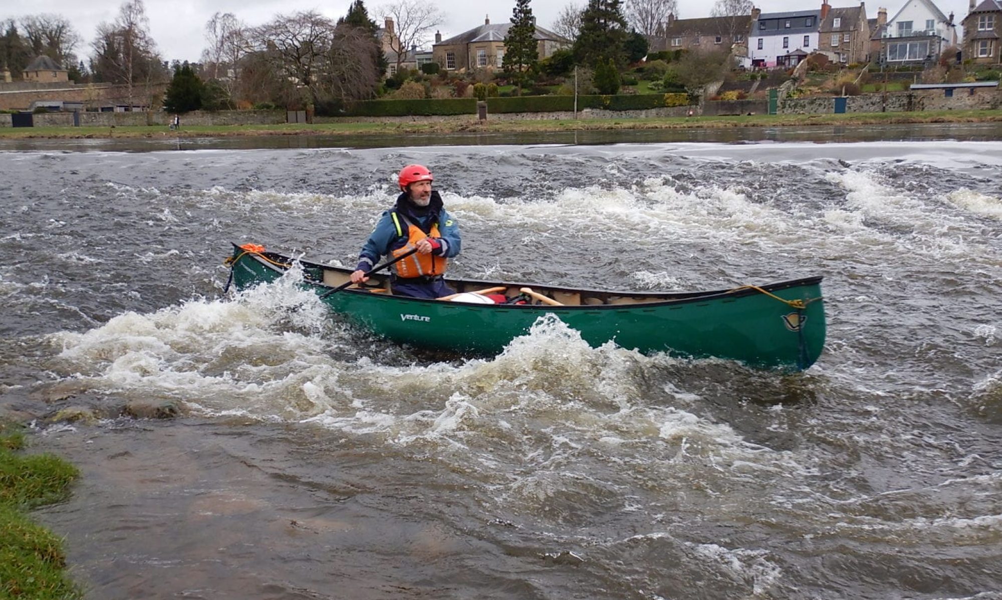
Paddlers: Tim, Francis, Geoff and Allan (for a time)
Route : Craigendoran-Kilcreggan and not back
Weather: Cold, wet and windy
Report:
With a calm wind forecast this was intended to be a practice trip to gain experience. As it turned out this proved to be an experience for all the participants with some valuable lessons learnt without any real problems.
Despite the forecast the wind was actually F3/4 and the sea was quite lumpy, possibly partly the result of a high wind the previous night. After a short uncomfortable time on the water, Allan decided to go back to shore. For the remaining three the paddle round to Kilcreggan was problem free, the weather improved slightly and overall it was a pleasant morning.
After coffee and cake at Kilcreggan we decided to cross to Gourock for lunch but 100m out we hit the main channel and a brisk wind. Given the tide had just changed and we were going to experience an increase in the sea state due to “wind against tide” this was quickly revised to a paddle back close to shore. Running downwind is not comfortable for the less experienced and after about half a mile we experienced our first capsize. This was quickly dealt with by righting the boat, popping in the paddler and pumping out. It was then decided that the best action was to paddle swiftly on in order to warm up. Lesson 1: After a capsize check the boat as well as the paddler and if necessary get to shore to empty the boat completely. We believe a hatch cover was not on properly and during the capsize a quantity of water had got into the forward compartment. Coupled with the inevitable quantity in the cockpit left after the pump out, this caused increasing instability and led to a second capsize.
The method used for the second capsize was a Scoop i.e floating the paddler into the boat, righting it and pumping out. Lesson 2.The scoop should only be used in the unlikely event that a casualty is injured or unconscious because the capsized paddler is in the water longer and the boat can get waterlogged. With water entering the front compartment this is what happened and the only solution was a swim to shore towing the capsized boat. Inevitably the paddler, without a wet or dry suit, got chilled. After a change into dry clothes (standard requirement) and some jogging about, the escape route identified in the risk assessment was implemented. This involved a phone call to get transport (in this case Allan was thankfully available) and a short paddle back into the wind (much more stable) to a beach just east of Kilcreggan with easy access for a car. By 3pm we were back in Helensburgh reminiscing on an eventful day.
Weather: Bright with little wind. Getting misty and damp in afternoon.Cold
Route: Crinan to Ardrishaig!
Report: Forecast strong winds and a desire to fill in the last bit of the Argyll Sea Kayak Trail led to the choice of fresh water and the Crinan Canal. Within these limitations it is a lovely paddle but with restricted landscapes and little of paddling interest.
We put in at the swing bridge at Crinan Ferry where there is space for 3 parked cars.
Hugh, Geoff and John at the start looking across to Crinan Ferry and the Sea
The low pontoons provided by Scottish Canals are excellent and the paddle to the first of the loch flights at Dunardry calm and attractive.
The StartThe Tranquil CanalThe first of the Dunardry Lochs, going Up.John on the portage
There are two loch flights between Crinan and Ardrishaig; Dunardry with 5 going up and Cairbaan with 4 going down. There is about 1 km between the two and it is a toss up whether you walk or paddle it. Portage Trolleys are essential and can be borrowed free of charge from the Canals Office in Ardrishaig. Contact them before you go as they are shut at weekends in winter, although the canals officer will come down to give them out. The two we borrowed were brand new.
The Portage
One problem was that one wheel on a brand new Decathlon trolley completely disintegrated and the kayak had to be carried. We have since established that a wheel on another Decathlon Trolley is splitting and close to disintegration. It appears that unlike pneumatic tyres, the solid plastic sand wheels fitted cannot take the vibrations of a track or tow path. Seriously Not Recommended.
Getting Duller and Wetter at the bottom of the Cairnbaan LochsArdrishaig and RainTim in Ardrishaig
The path down from the pontoon to the Car Park is quite lengthy and again requires a trolley. We are very grateful to Tim and Sheila for moving all the boats down whilst we went back up to get the cars.
The timings were exactly as expected for the 9 miles. Allow 3 hours plus 1 hour for breaks and portage. A very pleasant trip; excellent for Beginners and as a tranquil interlude from “The Breakers that give one the shakers” on the wide open sea (as described in the classic song The Crinan for Me).
Route: From Stronachalar north west to the end of Loch Katrine at Glengyle. Return back to Royal Cottage and thence Stronachalar
Report: A very misty and damp day which was not warm. Despite low visibility (cloud base usually lower than 100m above loch and sometimes zero) the scenery had real charm and the company was excellent.
Access on to the loch is problematic here, as at the east end. It is possible down a stream close to the cafe but we went from a slip not normally open to the public, to the west. The LLTNP Access Committee needs to get on to the issue of access to this beautiful loch.
The Gyle is a tranquil river up to the bridge but is blocked by wire soon after. Have they not heard of the Access Act? The Clan Gregor graveyard is of real interest having been raised each time the loch was raised (3 times).
View down to Clan Gregor graveyard
Heading up to GlengyleAs far as you can get up the River Gyle
It was a short day (about 10 miles) but very enjoyable.
Weather: Sunny with some haze (max 28C). Windy at times.
Route: Fethiye- Oludeniz-Patara-Kalkan
Report:
After much discussion about Greek Islands we decided that perhaps our best option was to retrace sections of our first trip (the Seven Capes) adding in sections at the start and finish we did not do and stopping to see other attractions we had not had time for in 2010.
A mid morning plane from Glasgow saw us at Dalaman airport at 3.30pm waiting for arranged transport that never came. Refreshments at the airport can only be described as a rip off with 85 lire (£22) for 3 beers compared to the normal cafe price of 30 lire. Eventually the taxi/people carrier turned up and by 5pm we were in an excellent and cheap little hotel in Fethiye, a lovely little town with a huge hinterland of hotels and self catered accommodation. Dean then met us and took us to the Fish Market where we had an excellent meal (of fish!).
The View from the hotel bedroom
The next day we purchased water, bread, cheese, wine and fruit and were the transported to our launch spot for a week’s kayaking.
The coast here is stunning, with massive limestone cliffs surrounding perfect little beaches. On occasions these are accompanied by expensive holiday complexes .
Holiday Complex, near Fethiye
The cliff scenery is magnificent with soaring verticals, caves and, on this section, two perfect arches.
Soaring Cliff SceneryArch 1Arch 2Cave 1
The kayaking in warm sea, sun and a breeze to prevent overheating, was superb. Every so often a turtle poked out its head, only to disappear as soon as the camera was turned on it.
Our first camp was on a beach along a fairly exposed piece of coast with some extremely noisy breakers. The beaches are very steep and the rough sea throughout the week, meant there was invariably surf. Not for the only time on this trip our landings were very wet with capsized boats and wet occupants. Experimentation with different landing methods never gave a “best” method.
Sunset and Camp Fire at camp site 1
After a sticky, noisy, sleepless night we headed for Gemile Island. This was a place we had missed last time because of time pressures and wished to visit.
Launching from the campsite
In the 8th century Gemile Island was an important and thriving religious centre dedicated to St. Nicholas (Santa Claus). Eastern Christianity (Orthodox) was completely dominant until the 13th century, and continued on until the ethnic cleansing of the Greek people of this part of the world in the 1920s. There are ancient ruins everywhere (e.g we had passed ruins of a monastery high up the cliff the previous day) and none more so than here where there were three churches, a large cistern (for water) and, most impressively, a long covered walkway.
As is usual, preservation and explanation is minimal. It appears that the Turks cannot cope with the number of wonderful historical sites they have and everywhere they appear under threat. The island itself gives superb views, all for 5 lire entrance fee(£1.25)
After Gemile we headed for Oldenitz, an attractive beach resort with a long sandy beach, for beer, lunch, water and supplies. All the landings were spectacularly unsuccessful to the amusement of the adjacent sunbathers. Post lunch we paddled on in increasingly lumpy seas towards a deep cut known as Butterfly Valley. It is still unclear why it was so rough. The wind was fresh in our faces F3/4 but the sea felt as if was the legacy of a big storm (F7/8) elsewhere. As we rounded the corner into Butterfly Valley, the last gulet (ferry) was leaving. As it hit the water we were paddling the passengers were whooping and hollering as if on a big dipper. The sea was rough.
The valley is a co-operative which also operates a camp site and camping huts. For 50lire we got camping, dinner and breakfast. The dinner was very Turkish, with a collection of vegetable mixes and bread. Not to everybody’s taste. Breakfast, however, was good, with boiled eggs, cheese, bread, as well as the normal cucumber, tomato and so on.
Butterfly Valley Campsite
After breakfast we travelled on to Yakkuk, where we had camped in some squalor last time out. It had been transformed with a brand new cafe/restaurant with a small pool and a number of self catering chalets. The track in had apparently been upgraded but the access was still mainly by sea. Afer coffee we embarked on the next section of the trip, which was the most committing with no road/track access for two days and limited landing.
Occasional ruins could be seen. We think the larger complexes were monastic; the land is too poor to sustain large-scale farming of any sort.
Ruined Monastery
Our camp site was on old terracing just above a small shingle beach. As with all our wild sites we had an excellent fire.
The next day took us along some outstanding scenery with a number of caves. The biggest and best of these we have called cathedral cave because of its size and light.
Wonderful cliff scenery with some swell to keep it interesting.
Cathedral Cave (note kayaker bottom left)
Eventually the mountains finish and an alluvial marshy plain becomes dominant. At the extreme western end a small river flows into the sea and we followed that up a few hundred metres before stopping by a restaurant/camp site where we ate and spent the night.
Campsite 4. Patara BeachSunrise at Patara
Patara Beach is an 11 mile long stretch of sand with surf the whole way along. At the far end there is a small area where, due to currents, the water is deeper and the surf minimal. Inland is the ruined city of Patara and our plan was to kayak the beach in the morning and explore the city in the afternoon.
Patara Beach
Everything went to plan. About 400m from the end the local authority have beach facilities; cafe, showers, toilets, loungers and a life guard, and inland from these is the ruined city.
The debating chamberMain Street
As with all things Turkish, only a fraction of the work justified by the size and importance of the city has been done.It has, for example, the oldest lighthouse in the world, but this is chiefly in numbered blocks scattered around the base.
Although the public are not allowed on the beach overnight in order to protect the turtles, because of the paucity of potential camp sites further on, we decided to camp where we had landed. We delayed until the sun set and then confidently assumed we would be left alone. This proved eminently satisfactory with any light from the fire hidden by the rocks.
campsite 5 &6
THe next morning we were just on the point of launching when it was noted that the already strong wind was actually increasing. It was decided that it might be wise to wait so we trekked down to the cafe to have coffee. When there we had discussions with the Beach supervisor who informed us that, far from going down in the afternoon , it was going up to a Force 6 and staying there until the early hours. We thereupon decided that we would spend the day surfing and sunbathing, with the wind hurtling about us keeping us cool.
The SurfNot quite like being caught by the weather in the Outer HebridesSunset at Patara
For the night we simply re-erected the tents (not quite as easy as it sounds because of the wind), lit a fire and lived the life. However we needed get to the next village/town by 11.30 to get back to the airport in time for our plane. So, for the first time, we were away before 8am. The final paddle was again a lovely trip with cliffs, caves and rock gardens.
Kalkan
Dean met us on schedule and took us back to the airport in plenty of time for the plane and home to Helensburgh by 8pm.
This was another fabulous trip and even the dodgy surf landings now seem like simply fun. Next year we will be going somewhere different but it is questionable if it can be as good.
Cost: Always of interest our fares, with hold luggage, booked seats and something to eat came to about £330 each. Kayak hire, transfers and hotel was £190 each. Other costs came to under £200. So, as with last year, the total cost (including the all important beeer) was just over £700
Access to the river at Drymen Showground is easy provided one avoids cow pats. The get-in from the shingle by the bridge gives the only swift water on the whole river to Loch Lomond. The rest is slow, very, very meandering and shallow at times.
Drymen Bridge
It took us the best part of 2 hours to get down with the currrent; the straight line was around 3 miles. However with excellent company it was a pleasant experience.
The Group on the river, with Conic Hill in background
From the exit the route crosses very shallow sandbanks. Less water in the loch and we would have been carrying. At Balmaha Tim and Allan peeled off in order to get home for evening meetings. The rest carried on to the Loch Lomond Sailing Club for a look at the vintage canoes/kayaks before returning to Millarochy Car Park for the cars home. An excellent cup of tea and cake in Drymen completed a very pleasant day.
Route: Loch Pooltiel (Skye) to Lochmaddy (North Uist)
Report: With settled high pressure giving very light winds it was decided at less than 24 hours’ notice to attempt the crossing at 0700 on Saturday 17th October (having not managed any of the other feasible dates) when tidal streams and wind gave assistance. The short notice resulted in only two experienced kayakers being available. Having camped overnight at the launch site on Loch Pooltiel on Skye we departed in semi-darkness at 0720 on a N going tide and with a light SE breeze. Although it had been very cold overnight both of us wore light clothing for the crossing and were very comfortable. During the crossing two pods of dolphins (10+) came and said hello, one even jumping between the kayaks. Only two vessels, a freighter and a fishing vessel were encountered, one at close quarters. The GPS recorded only 12 minutes of stoppage time of which 7 minutes was the single food stop. The rest were photographs and navigation checks. The crossing to the entrance to Lochmaddy was timed at 4.5 hours and the ferry terminal 5.33 hours. Total distance recorded was 16.7 Nm (19.25 miles, 31k) at an average speed of 3.24 knots (6 km/hr). After getting ashore the beer in Lochmaddy Hotel tasted superb!
The “Grand Depart”Dawn breaks behind usSue, dolphin and North Uist in distance20 km covered, 10km to goNearing LochmaddyWAiting to Load kaaks on ferry for 11.15 ferry home on Sunday


