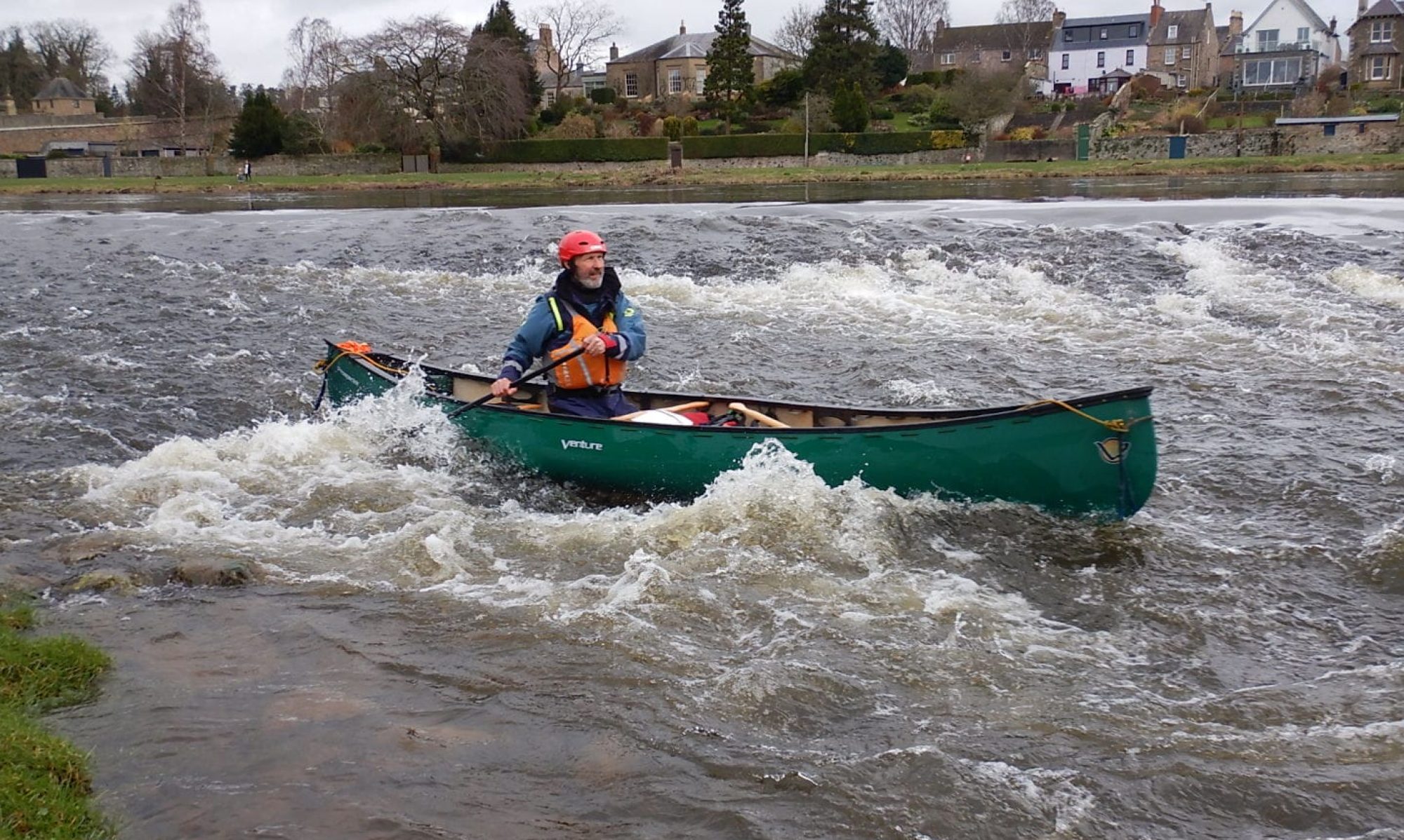
Report: All previous “Thursday” meets had been cancelled due to the weather and we hope numbers will start to climb as it becomes part of the established pattern of events. Finnart was a new destination for Tim and Robert and, as ever, the landscape was sublime.
Looking north up Loch LongLooking south to the light at the entrance of Loch Goil
The paddle started and ended by a huge tanker tied up at Finnart. The Ashna is owned by an Indian Oil Company called Essar, and has a Gross Tonnage (crudely how much it weighs) of 156,417 and a Deadweight Tonnage (how much it carries) of 301,000 tonnes. By comparison the biggest cruise liner in the world has a GT of 225,282 tonnes but a DT of only 19,700.
VLCC Ashna
From Finnart we crossed to Mark and after a quick inspection , that confirmed everything at the Bothy was in excellent condition, we pushed on to Carrick Castle for lunch.
Looking up Loch Goil from the picnic spot at Carrick Castle
A leisurely lunch was followed by a paddle along the south shore to the point where we crossed Loch Long. A pleasant paddle, with a light breeze behind us, brought us past Portincaple back to Finnart by around 2pm. Total distance was just over 12km in just over 3 hours paddling time. A lovely relaxing day.
Weather: Broken cloud (but a lot of it), some heavy rain and potentially windy.
Route:
Report
The weather forecast was of strong wind and rain . We started off with an easterly that helped us across to the pier at Strone for some elevenses.
Heading past Cove in the rainA break at Strone Pier
From Strone we headed south along the seafront of Dunoon. The cloud over the hills was, at times, spectacular, particularly when illuminated by the odd shaft of sun.
We lunched at the far end of the Dunoon promenade which was surprisingly busy as people grabbed the dry and almost sunny period for a walk (normally with dog). After lunch we headed east to the old lighthouse that marks the Gantock rocks whose most famous victim was the Waverley.
The Gantocks light
The shallow water and rocks here produced some interesting and surprising tidal eddies. A short investigation then on to Cloch lighthouse. By now the wind had shifted to the South West. After a short break just past Cloch to unjam skegs and answer the call of nature, we headed back directly to our launch site at Kilcreggan. With wind assistance the 3 miles was quite quickly covered and we were back by 15:00 . Another good day
With two late call offs only 3 of us set off from Inveruglas for a trip around the north of the loch. The initial target was to view the Pillar Rock roadworks from the loch. From there we headed up to the end of the loch, in part to investigate the Outdoor Centre. There was little obvious life. We finally landed at the deserted township of Ardleish. In summer there is a pedestrian ferry here from the West Highland Way to Ardlui. The buildings and cottage, however, are wrecked.After some lunch we headed south into a stiffish breeze to “Island I Vow”. This is a lovely place with glorious views north and south and what appears to be a nice little camp site.
Looking NorthLooking SouthThe Campsite
The next target was the Inversnaid Hotel. This used to open for the whole year but is now closed October 25th to March 25th. A large black wild goat showed interest in proceedings as we looked at the hotel and waterfall. Our final paddle took us back across the loch to the cars and home. An excellent paddle in stunning scenery.
Route: We chose the only extensive length of the coast within driving distance of Dalaman Airport and our kayak supplier, that we had not paddled in previous years. This ran from Marmaris to Gocek and proved to be equally exciting with spectacular cliff scenery.
Weather: 6 days of sunshine with temperatures at around 26c. Nights cool enough to sleep (21C). Sea breezes kept us cool but picked up in the afternoon to add a little challenge to the kayaking.
Report:
Day 1: Arrived at Dalaman at 10.30pm local time after 4 .5hr flight and with 2hr time shift. Met by Dean (supplier) and travelled to Icmeler (near Marmaris) for night in small hotel. After a couple of beers, bed by 02:30.
Day 2: After breakfast and some shopping for supplies (notably 30 litre of water) we set off for ourlaunch point in Marmaris.
Breakfast
The previous days storm was working itself out and the first, short, paddle back to Icmeler for launch was quite bumpy.
launch
After lunch the wind dropped and we headed out of Marmaris Bay for the wild coast of this part of Turkey.
Heading Out
Beaches and camp sites are not frequent and getting one at the right time is always problematic. The first night we found a long shingle beach backed by a pine forest. Within the forest were a couple of clearings with the remnants of what appeared to be bee hives and temporary habitations. The sites were dirty but we had little choice and pitched whilst making our fire and doing the cooking on the shingle.
A big problem was a major leak into the rear compartment of Geoff’s boat. This appeared to be coming from the top of the skeg box where the wire went through the hull and an earlier repair had failed. The combined weight of the paddler, camp equipment and supplies for a week coupled with the rough water in the morning had led to significant incursions which got progressively worse as more water got into the rear compartment. The best repair seemed to be taping up the whole box.
Camp Site 1
Day 3: Dawn was around 7am and was normally the best part of the day, cool, calm and beautiful.
Dawn; Day 3
We normally got up around 7.30 (some earlier) and got afloat between 8.30 and 9. This day, however, we were much later. To avoid any contact with the Turkish Navy, whose main base is in the next bay to Marmaris,we headed out towards the island of Yilancik Ada.
Heading for the island
Landings were rough and upon inspection of Geoff’s boat found that the tape had become damaged and water was again entering the boat. Further repair included a cane buffer over the tape to try and absorb any impact with rocks. With regular inspection and re-taping this worked for the rest of the trip.
Back to the mainland and the exceptional cliff and cave scenery.
One of the many caves on the coast only really accessible by kayak
Camp Site 2
The next camp site was on a long isolated beach. To the west it was shingle backed by a pine forest but the eastern end was sandy and open. As on the previous day there were clearings in the pine forest and deserted hives. There were also wild donkeys and evidence of larger animals (cows and wild boars). A golden eagle circled overhead. Remarkably for such a large flat area there were no tracks and no evidence of permanent habitation. Apart from sand everywhere the camp site was very pleasant (and wood for the fire plentiful).
A gorgeous sunset
Day 4: Another glorious morning.
Early morning view from the tent
And onwards. The coast was wonderful, with huge limestone cliffs, stacks, caves and arches.
Coastal Cruising
Turtle Beach is a long sand beach that crosses the wide Dalyan valley. The river up to Dalyan is restricted to local passenger boats that bring people from the town to the beach. It is apparently possible to use the waterway before 10am but we opted to simply paddle along. The beach is an internationally protected zone for turtles (Green and Loggerhead) and unknown to us, the public is not allowed in the area between 8pm and 8am. This restriction is not obvious and we paddled to the far end, close to dusk. A suitable site in a picnic areas was identified and we started to erect the tents only to be accosted by a man in uniform with a whistle. After trying to explain we could not go on because of lack of landing places and darkness falling he summoned an English speaker who managed to explain our predicament and get us permission to stop . The conditions were no fires or lights, kayaks completely off the beach area and an early departure (8.15am) , so we had a rather bleak early night.
Camp Site 3: Turtle BeachSunset at Turtle Beach
Day 5 The daystarted with some of the best limestone scenery in the world.
This was followed by a 5 mile sand beach that started in a hilly area at Sangerme Park which consisted of four expensive hotel complexes. We had expected beach bars but everybody was apparently on an “all inclusive” holiday (which included all water sports and food/drink). The reps at the German hotel, having explained that there was no where we could get a cup of coffee or beer, provided one free.
Coffee Time
The main beach is the end of Dalaman airport and is dirty and bleak, with no facilities. After lunch at the east end we were back to the cliffs searching for a camp site/beach. At this stage we came across one of the best caves of the trip
Blue Grotto
Hugh had identified potential landing spots and camp sites from examining Google Earth. Some of these were impossible but generally they were OK as in the next case, a small bay on the south side of a high saddle at the end of Gocek Bay.
The evening ushered in the most spectacular of sunsets and another superb fire.
Day 6 The good weather had resulted in a calm trip . Rounding headlands however is always slightly problematic because exposure to the ever present swell generates clapotis. On day 6 we rounded the final cape to go into the more sheltered Bay of Fethiye. Again there were no troubles although there was a very slight tide race at the point
The paddle into the islands to our lunch stop seemed to take a long time and after a prolonged break the wind had got up from the south giving us a tough final couple of hours to our final camp site which were some small terraces adjacent to a small restaurant catering for yachties.
Camp Site 5
Day 7 The final day involved a 12mile trip through the islands to the village of Gocek. This bay was probably the least interesting scenically and undoubtedly the busiest in terms of craft. Every inlet had a minimum of two or three boats and if there was a cafe and pontoon a more usual number was 20-30. Whereas 5 years ago most of the boats had either been yachts or gulets (local boats catering for tourists) now the area was awash with huge motor cruisers, many U.S. flagged. Including those tied up in the marinas in Gocek, boat numbers in this tiny section of our trip must have run into thousands. The biggest of all, flying the red ensign, was Delbar; owned by a Russian billionaire.
A small private yacht! Note helicopter.
We arrived in Gocek mid afternoon, time for a beer and an ice cream before meeting Dean for the trip back to the airport.
A well earned beer
Dean arrived 4.30 and after repacking from the kayaks into our travel bags we had an excellent meal.
The airport journey and check in were uneventful, flights were on time and we were back home by 2.30am. An excellent trip.
Some Facts
Cost: Flights £300, Kayak Hire and airport transport £200, Meals, Beers, Airport Parking etc £150. Total £650
Distance Covered: 150km(95miles). The most we paddled any day was only 14.5Nm (18miles)
Weather: Wonderful. Breezy (F3/4) mostly sunny on Saturday; Cloudless and calm on Sunday
Report: This was intended as a paddle for those relatively new to sea expeditions (first or second time) but sadly none could make it. Having left Helensburgh slightly late we spent about an hour searching Roshven on Loch Ailort for a suitable place to launch. Having found one ideal spot we were accosted by a woman proclaiming it was a private road (it was not) and we could not leave the cars on her ground. Fortunately there was an excellent launch site just on the Glenuig side of Roshven and after lunch we were off into a pretty stiff breeze with a determined chop.
Heading West
We made good progress and our first stop was an excellent beach just at the mouth of the north channel. This would also make an excellent camp site.
At the mouth of the North Channel
The scenery was breathtaking and got even better as we headed down the channel.
The North Channel
The channel dries at low water but not for long. From the exit (where we met three paddlers from the South) we headed for one of the best camp sites in the country. This is a glade site with excellent wood supplies and fantastic views. A pleasant evening around the fire led to an early evening and a cold, clear night
The Camp Site
The morning was simply stunning; cloudless and flat calm. The views from the site were sensational in the morning sun.
The worst bit of the site is undoubtedly the low water launch where a carry over squidgy mud is required. However once through that and the paddle recommenced, within 5 minutes you come across the beautiful Castle Tioram.
Castle Tioram
The Castle is joined to the mainland by a tidal causeway and was the seat of the Clan Ranald. The inside was destroyed by fire in 1745 when the chief and his clan left to join Bonnie Prince Charlie and was never re-occupied. Recent attempts to rebuild and refurbish were prevented by Historic Scotland.
A short visit and we were off up Loch Moidart heading for the open sea past seals and, I am assured, otters. The scenery was stunning, the sun was hot, the sea was clam and all was wonderful as we rounded the headland and pulled up into Ardtoe. This is really simply a very minor road end with some caravans and a lovely beach. Lunch followed and some sun bathing and then off again round the outside of Eilean Shona.
Map of Route
Our next stop was an island close to the mouth of Glenuig Bay with lovely sandy beaches. A second lunch and more sun bathing.
Heading up Loch Ailort
The final paddle east was, like most of the trip, superb; indeed even the car trip back to Fort William and on through Glencoe was wonderful. All in all a fantastic trip
Paddlers: Geoff, David and Jamie Weather: Bright and very breezy (F3/4)
Route: Kilcreggan, Gourock, Cloch Point, Cardwell Bay, Inverkip and v.v.
Report: “Exploration”-investigating new areas or new perspectives-is an important part of the appeal of sea kayaking. However finding unfamiliar areas for short day trips can be difficult. This route was chosen simply because the coast was less familiar than most. Kilcreggan was chosen to give us an extra hour of paddling south than from a Helensburgh launch. The launch point was about 400m along Fort Road (turn sharp left at bottom of hill at entrance of village) by the entrance of the Portkil Estate. The beach here has been cleared of large stones to allow easy motor boat launching and there is good parking. We were afloat by 9am.
The previous day had seen F5 north easterly winds and although the wind had dropped to a low F4 there was still considerable swell which led to an “interesting” if fast crossing.
Heading south by Cloch lighthouse
With a strong wind on our backs we rounded Cloch Point for our first stop of the day in Lunderston Bay by the Cardwell Bay Garden Centre. This is an excellent landing with a sand beach, seats and a large flat grass area.
Lunderston Bay (Cardwell Garden Centre)
After some relaxation in the sun, we headed on south for Inverkip in the strong breeze always conscious that every km south would be a fierce battle north. The views both north (Loch Long and Argyll Forest Park) and south to Arran were outstanding. The removal of Inverkip Power Sation and its huge chimney has improved the area immeasurably.
Heading South
After mooching around “Scotland’s Premier Marina” we decided to begin our battle back home. We progressed well and were at McInroy’s Point (the Western Ferries dock) for lunch. There is quite a good beach just to the west of the point. One item to note were the weekend “huts” perched on the edge at Cloch Point. These seem to have been built on old gun emplacements.
Looking North
After a long lunch break we paddled along he Gourock prom to the Cal-Mac terminal keeping in as much shelter inshore as possible. From Gourock e crossed back to Kilcreggan, the wind having dropped to a F3 and shifted slightly to the south. We were back by 3.30. An excellent day.
The poor weather forecast (high winds) , unavailability and illness caused a change of time and venue from round Jura to the south east side of Coll and Tiree. Even then we expected high winds and very rough water, especially in the Sound of Gunna, between Tiree and Coll. In the event, although the breeze was apparent, the water was flat and the sun shone and shone, with over 15 hours on both days.
Just like bikes, kayaks are carried free on Cal-Mac ferries. Carrying the boats on to the ferry in Oban we learned the most important lesson of the trip; USE A TROLLEY. The ferries are big, but the link spans are even longer. With three of us we needed a minimum of 3 trips the length of both. Whilst the Oban carry-on was just tolerable, the length of the boat plus the the length of the link span at Scarinish (Tiree) was close to half a mile, and it took close to an hour of hard labour to get to a point where we could get into the water. By the time this was completed we were very tired and it was 7.30. The original plan of paddling for an hour was thereupon abandoned in favour of camping on the flat land adjoining the Cal-Mac office (and the water supply and toilets) and a trip to the pub.
Camp Site 1
A pleasant enough evening followed with a lovely walk of just over a mile and we turned in at about 11.30pm. At 6.45 a loud metallic clanking indicated an early shift by some construction workers at the pier, and at 7am a jack hammer started breaking up a lump of concrete. This continued intermittently for the next hour and a half. By 9 am even Ken was ready to depart.
Beach by office, Tiree
The most memorable feature of the islands are the glorious beaches, huge, like Gott Bay or tiny coves tucked between the rocks. On Gott Bay can be found the extraordinary cottages peculiar to Tiree. These have rounded roofs covered in pitch (or thatch) and huge walls to deflect the constant wind that blows over the island.
The breeze was continuous and would have made any attempt on the North West coast untenable, or at least very unpleasant. For us it simply provided cooling of an increasingly hot sunny day. We got across the potentially difficult Sound to the island of Gunna for lunch.
Gunna has lovely beaches and a large flock of completely black sheep. It also has a cottage that is not new but fails to appear on any map. After lunch we paddled on to Coll and climbed to a trig point to look at the north side, confirming again it was not possible.
The North Coast of Tiree
After a snooze we pushed on south. At this stage Hugh claims to have seen a Basking Shark. The paddling was wonderful with lots of seals and islets to meander around and through.
The look out for a campsite with drift wood for a fire led us to a small cove near the mouth of Braccadale Bay. A leisurely meal and an excellent fire preceeded a good night’s sleep.
Camp Site 2
The next morning we had a very casual (and late) departure for a short day paddling a wonderful coastline in fantastic weather. Even the breeze dropped. Our first stop was Braccadale Castles (old and new) the ancestral home of the Laird of Coll.
Old and New Castles
A lot of money appears to be flowing into the castles to provide holiday accommodation. In the weather we had, it is difficult to imagine anywhere nicer.
We paddled on surrounded by seals with excellent views to Mull, Ardnumurchan and Rhum. At one point an Otter ran up a rock just in front of us, saw us, turned and ran down back to the water.
After a great afternoon, the only small problem to be solved was how to get the kayaks back on to the ferry. On the route out we had inspected the pier at Arinagour (Coll) for good, indeed any, landing points and potential camp sites close by (the ferry was at 9.40 the following morning). After much discussion it appeared that the only possibility was a landing on the rocks at high tide or a walk of a mile plus from the village. Given the choice of high tide at 5.30 pm and a ferry due out at 7.20 pm or high tide at 6 am the following morning and a 3 hour wait we decided on the former. A trip up to the village and the pub, then back to the pier and a surprisingly easy lift out over the rocks. Note that this would only be an option in the very calm weather we experienced.
The ferry was late and, by the time we had carried the kayaks and gear the length of the boat and up the ramp, it was after 11 p.m before we were ready to get going for Helensburgh.
This was a great trip to three wonderful islands but access to and from the ferries is real problem. A trolley would have halved the time and quartered the effort and would have been essential on Coll in poor weather. Carrying a trolley (or storing it) is problematic and subject to further investigation.
Report: The plan had been for a weekend trip to the Garvellachs but the wind was forecast as 5 with potentially gale force squalls. Instead it was decided to do a training run (part of the sea kayak training course) departing from the RCYNC at Rhu. There was a very pleasant run up the loch with the wind to Garelochhead for lunch.
Lunch
The journey back into the wind was significantly less pleasant but successfully achieved by all. A good, if short, day.
Weather: Calm. Overcast with summy intervals and periods of heavy rain in evening.
Report: Departed from Aldlochlay close to noon Saturday and paddled to Inchonnachan for lunch and some exploration of the old summer house..
Departure
From Inchconnachan we headed over to our camp site on Inchtavannach and pitched. After some debate we then proceeded on a late afternoon paddle around Inchmoan before dinner. During the paddle there was heavy rain which continued on and of throughout the evening. Most of the youngsters decided on a swim before drying out in front of an excellent fire. A pleasant, if occassionally wet evening was had by all.
Sunday was calm and sunny. We left the camp site about 10.30 and paddled over to Inchgalbraith and its ruined castle.
At the castle window
A slow leisurely paddle back to Aldlochlay followed, arriving just before noon. A very successful conclusion to a successful course.
Weather: Lovely but windy on Saturday getting less windy but more cloud as weekend progressed, with heavy showers day and night.
Route:
Report: Slightly late we left Helensburgh at 7.30 aiming for the 10.20 from Lochaline to Mull and made it easily. A rather slow drive across Mull got us to Ulva Ferry around 11.30 and on the water at 12noon.
Departure ;Ulva Ferry
There was a brisk northerly F4 blowing but a decision was nevertheless made to go on the north side of Ulva, with the option of cutting through the channel between Ulva and Gometra if there was doubt about the crossing to the Treshnish. So it proved and we stopped at the wee bridge joining the two islands for a break and because the channel was still dry.
Bridge joining Gometra and Ulva
By the end of lunch the channel had still not filled sufficiently so we waded through. Almost immediately after resuming the paddle a Sea Eagle appeared soaring above us.
Sea Eagle above Ulva
The original plan had been to creep up the end of Gometra before crossing but it rapidly became clear that we would need to wait for the wind to go down. We stopped at a potential camp site with a view north with a poor landing on wet, seaweed covered extremely slippy rocks and waited in the sun
A snooze in the sun
By 6pm it became clear that progress was not going to be possible and this was to be the camp site. Here is where the Strops come in. Hugh had designed a pair of lifting strops that proved a godsend in getting the loaded boats up (and down) over the terrible beach. These proved invaluable.
Strops in Action
If there are four of you and you have strops, the camp site is strongly recommended with large relatively flat area, good pegging and a supply of driftwood. The latter provided the fuel for a good camp fire with turn in sometime after 11pm with an agreed rise at 7.oo for a departure at 8.30. Otters also frequent the area.
The Campsite (with Staffa in background)
Overnight there was heavy rain which damped both tents and wind. However it stopped at 7 and stayed away most of the morning. We headed directly for Carn na Burgh into the increasing wind. Although both islands have fortification and history both have terrible landings with Beag almost impossible. The views however were fantastic.
view form Carn na Burgh Beg south to More with Lunga in distance
Some History: The two islands have a long history as part of the boundary between the Norse and Gaelic cultures. Easily fortified they were used in a number of clan battles including the battle between the Maclean’s and Argyll in 1680 that ended with the supremacy of Argyll. Its last use was during the 1715 rebellion when it was occupied for the Jacobite cause by the MacLeans whose chief had been imprisoned by Argyll.
The paddle was then south to Lunga past Fladda and a host of islets and skerries. The wind had been picking up all morning and winds caused a few flutters as the kayaks surged forward. The landing on Lunga was again on rocks although they were somewhat smaller. There we joined yachtsmen and tourists off the multiple boats that operate from Fionphort, Bunessan and Ulva Ferry. The attraction was the magical puffin colony where hundreds of Puffins in their Sunday best parade for the camera.
Aiming for the Photo Competition
Puffins and Wildflowers
Puffins and Kayaks
The numerous tourist boats were eventually joined by a Cruise Liner!
Cruise Liner Calls
From Lunga we headed directly to one of the most incredible places in Scotland. Staffa is formed of nearly perfect hexagonal vertical columns of basalt sandwiched between sandstone and at its most magnificent has three large sea caves.
Mackinnon’s Cave
Mackinnon’s Cave is the largest with a wonderful vaulted entrance. The Boat Cave is the deepest and houses a pair of nesting guillemots. In their distress at being disturbed they accurately dive bombed Ken with rather smelly faeces. Ken alone was not amused at this sign of good luck.
One amazing phenomenon at this point is the tilting ocean. The columns are vertical on the sandstone but the sandstone layer is slightly tilted. It seems impossible for the brain to cope.
Sloping Seas
The third cave, Fingal’s, is the masterpiece with vaulting throughout its length.
The public are able to access the cave by a path at the base of the basalt. The tourists during our visit not only had the magnificence of the cave but 5 beautiful sea kayaks to admire.
The path to Fingal’s Cave
We had a quick break at the only “beach” at Clamshell Bay, another rough rocky landing. After much discussion we headed back to Gometra in degenerating weather, reaching there about 6pm. It had been a fantastic sea kayaking day with two amazing natural phenomena and around 20 miles of excellent kayaking in fantastic surroundings.
Monday promised a relatively short paddle along the south side of Ulva to get us home for early evening. The cliff scenery was excellent the whole way and the wind , now from the South, had little impact. We stopped at a private bothy at Cragaig used by at least one kayak club. Perhaps a winter trip?
The Ulva BothyBoats at the Bothy
We arrived back at Ulva Ferry at about 1pm and decided to take lunch in the Boat House cafe on the island. This was excellent (if slightly expensive) and the Heritage Centre (Free) was well worth the 2 minute walk from the cafe. In stark terms it described the clearance of Ulva/Gometra from a populationof 850 at the start of the nineteenth century to 15 in 1981.
 Weather: Calm with hazy sunshine at times. Cold


