Report: On October 31st the coastguard at Greenock will close leaving emergency service for the west coast of Scotland to be co-ordinated from Belfast and Stornoway. To recognise the significance of this action (and protest against it) ships and boats congregated and used the opportunity to release out of date flares. The club group, armed with flares, organised a night paddle across in a brisk Force 4 which made an interesting return journey. Following are a few of the spectacualr photos taken by Seylan
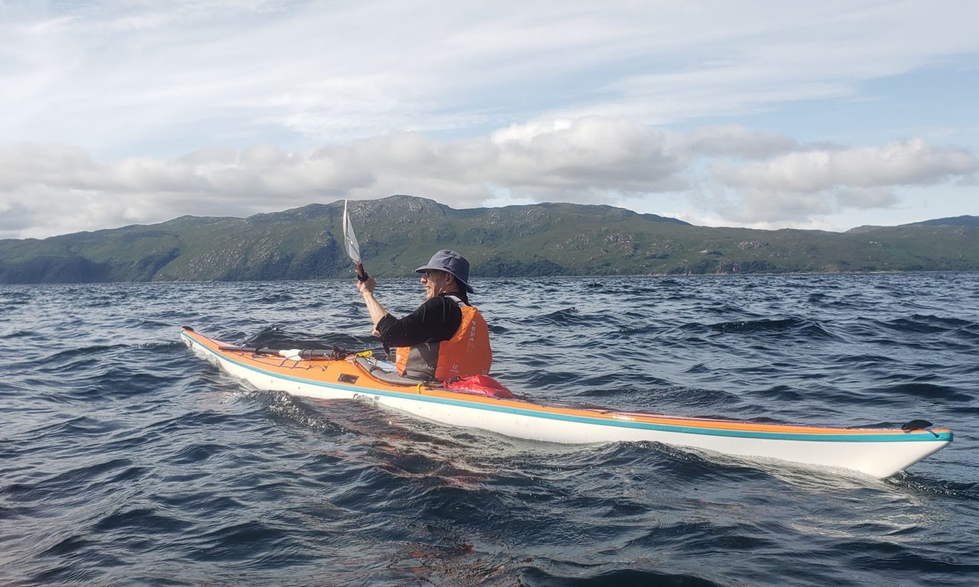
Report: The weather forecast was fantastic; flat calm and sun. Ideal, we thought, for the crossing to one of the big challenges for sea kayakers, Ailsa Craig. The rock, situated in the middle of the entrance to the Clyde is 10 miles from the Ayrshire coast and around 15 miles to Arran and Kintyre. Journey time was estimated at 2.5 hours.
Ailsa Craig
The first indication that we would not enjoy the promised flat calm were the flags flying straight. Either they were very light nylon or it was breezy. The white flecks on the sea suggested the latter and so it proved with a force 3 from the west throughout the day generating a significant quartering swell to paddle into on the way out and generate a tense trip back.
A terrible journey down (traffic jam on the M8 , lost in Irvine and lost in Girvan) meant a much later depart time than planned but an excellent parking spot and beach was found just north of Lendalfoot.
At 11.20 we were off and for the next two and a half hours paddled into the breeze, the rock on the horizon slowly growing into a sizeable and substantial island, with shear rock faces rearing up to 320m (1000ft). The time passed quite quickly as the chop provided interesting paddling and after 2hrs 40 minutes we were standing on the island.
The island itself is well worth a visit. A tramway runs up from a shingle/boulder beach and splits with one branch to the old curling stone works and the other to the lighthouse complex, now fully automated.
The tramway with Arran beyondThe tramway winch house
Just under half way up the mountain is a small ruined castle, reached by a precipitous path up the face of the crag. The tower is surprisingly well preserved. The views to the east are spectacular. We can only imagine the views from the summit as we did not have time to make the whole climb.
Looking down to the lighthouseAt the castle looking back to Lendalfoot
With a target return time of 7pm, by 4.30 we were heading back to the boats, leaving around 4.40. With the breeze behind us we thought we might be significantly faster but in the lumpy conditions time had to be spent on support and correcting strokes. Thus the return took only 10 minutes less at 2hrs 30 mins.
None of our photos catch the size of the swell; try taking your hands off the paddle when being chased by a wave. Again the time passed quckly because of the interest generated by the sea conditions. Whilst not frightening there was always a need to focus.
By 7.30 we were packed up and Girvan bound for a much needed drink and food. A really good day.
Report: The sort of evening when sensible men seek shelter from the rain can sometimes be near perfect for kayaking. So it proved with a trip east to Cardross on an incoming tide that allowed us well in to the village. A noticeable feature of the return was the tide, which was noticeable. A good evening.
July 25th
Paddlers: Ruth, Jim, Geoff, Bill, Sam, Oliver,Damian,Stella, Ross and Hugh
The paddlers minus photographer Hugh on Ardentinny beach
Route: Coulport, Ardentinny Village, Ardentinny Beach, Coulport
Weather: Calm and Bright.
Report: A well attended paddle across Loch Long. Ideal for beginners, the main interest was the slight swell and the paranoid police patrolling the unmarked “exclusion” zone and the road. A strange night.
Paddlers: Anne, David, Jamie, Douglas, Hugh and Geoff
The Route
Report:
This day trip to the east coast was a rapidly arranged alternative to a west coast weekend, dropped because of the gale force winds forecast for the Sunday. Initial forecasts for the Forth were for a Force 2/3 westerly (9-10 mph) although the BBC suggested Force 3/4 likely. Some protection because of the wind direction was assumed. In reality the wind was force 4 plus, with no appreciable protection and one highlight was some excellent, if unexpected surf.
North Berwick Beach
As we arrived at North Berwick (after a 2 hour drive) a large group was crashing out through some big surf. This group were from Lothian Sea Kayak club and were on a 3 Star Training day. We overtook them later and eventually they spilled up on our lunch beach. In some cases their efforts to land in the surf were spectacularly disastrous.
Lothian Club
When we eventually set off from North Berwick we also headed east with the strong wind behind us. This was at times quite exhilarating and always a bit nervy. Hugh manged to find the tiny (“smallest”) natural harbour just beneath Tantallon castle .
Hugh finds the harbourSlip found by DaveSlip with castle behind
Inside the “smallest” harbour
The castle itself is also quite spectacular.
Tantallon CastleSeacliff Beach (by Tantallon)
We lunched on the beach by Tantallon. For future reference this may be a better launch point with adequate parking space (unlike the mayhem of North Berwick) and a toilet block.
Lunch
After lunch (and an incorrect assessment that the wind was dropping) we set off to paddle the mile or so to the Bass Rock itself. The crossing was quite smooth and the caves by the landing quite spectacular. The gannets were there in incredible numbers with some still at the fledgling stage. The smell and muck on the water were also evident.
One of the three caves
The white dots are GannetsAnn
The swell was substantial with up to 2 m in the cave and at the landing point. Landing was clearly not possible.
Given the continuing wind and heavy swell, going right round of the rock was not contemplated and we set off for the next island, Craigleith, some 5.5km straight into the wind. For the best part of 1.5 hours we battled in to that wind, seemingly hardly moving but unaware of any alternative but to keep on going. The island itself appeared to offer some shelter but, as happens occasionally it simply magnified it. It is also not possible to land except in flat calm. Conditions by the island were awful so we immediately set off back towards North Berwick arriving on the beach just after 4, some 5 hour of paddling.
In summary the trip was exhilarating at times, exhausting at other times and always “interesting”. It was well worth the journey to the East.
Route: The original trip had been for the Treshnish Isles but a forecast of high winds for the Tuesday led to this more sheltered trip along the north coast of Ardnumurchan.
The Route
Day 1: Loch Ailort fills and empties with some force. Given the tide timings, the sensible option was to go with the flow rather than against it and start in Loch nan Uamh returning to Loch Ailort. Cars were then strategically arranged to enable such a route. Weather was overcast with occasional showers and some breeze but nothing to worry. Scenery, as ever, was staggering both forward to Eigg, Muck and Rum and behind over the mountainous mainland.
Paddling down Loch Nan Uamh
The beaches on the trip were superb; beautiful, sandy coves fringed by rock and forest.
A typical beach for a coffee break
After lunch we investigated a”vitrified” fort on Eilean nan Gour at the entrance of Loch Ailort. Vitrification is the melting of rock in a wall to fuse the elements together, a process which is almost impossible to reproduce and consequently quite rare.
The island itself is bounded on all sides by precipitous gneiss rocks; it is the abode and nesting place of numerous sea birds. The flat surface on the top is 120 feet from the sea level, and the remains of the vitrified fort are situated on this, oblong in form, with a continuous rampart of vitrified wall five feet thick, attached at the SW end to a large upright rock of gneiss. The space enclosed by this wall is 420 feet in circumference and 70 feet in width. The rampart is continuous and about five feet in thickness. At the eastern end is a great mass of wall in situ, vitrified on both sides. In the centre of the enclosed space is a deep depression in which are masses of the vitrified wall strewed about, evidently detached from their original site.
In reality the views are more impressive than the fort!
The view from Eilan nan GourHugh photographing a portion of vitrified wallDescending from the Fort
From the island we headed west towards the mountainous island of Shona and entered Loich Moidart via the North Channel. Possibly the best campsite we have ever found was located on an islet just to the south of Shona, offering flat pitches, plentiful wood and wonderful views. The slight breeze kept all the midge life away. An excellent and convivial evening for all. (24km, 15mi)
Campsite on tiny wooded island adjacent to Shona Beag in Loch MoidartThe campsite; Loch Moidart
Day 2: Castle Tioram, just 0.5km from the campsite, was the first port of call.
Castle Tioram
The gospel according to Wikipedia reads as follows:
The castle is the traditional seat of the Clan MacDonald of Clan Ranald, a branch of Clan Donald. Castle Tioram was seized by Government forces around 1692 when Clan Chief Allan of Clanranald joined the Jacobite Court in France, despite having sworn allegiance to the British Crown. A small garrison was stationed in the Castle until the Jacobite Uprising of 1715 when Allan recaptured and torched the castle, purportedly to keep it out of the hands of the Hanoverian forces. It has been unoccupied since that time, although there are some accounts suggesting it was partially inhabited thereafter including storage of firearms from the De Tuillay in the 1745 Jacobite Uprising and Lady Grange’s account of her kidnapping.
The castle is now in extremely poor condition and in 1998 was closed to the public at the request of Highland Council; a major structural collapse occurred at the north west curtain wall in 2000.
Controversial proposals to restore the castle by the new owners, Anta Estates, were announced in 1997 and received planning consent from Highland Council. This included the creation of a clan centre/museum, domestic apartments, and public access. However, Historic Scotland refused Scheduled Monument Consent – a decision upheld after a local public inquiry.“
The castle is well-preserved but clearly degenerating and maintenance desperately needed.
Despite the usual Danger signs, access is easy and rather precipitous ladders take you up to the top. The view is fantastic.
Inside the castleThe view down the loch to the seaRuth the Builder!
From the castle we headed north east down the south channel to the sea then east. The wind was increasing to force 4/5 from the south east which gave a bouncy ride as the kayaks were hit side on by the surf.
At Elgadale, a pleasant isolated beach just around the headland, a long lunch was taken.
A Valley Nordkap with Ruth and Ken
Getting ready after lunch
Decision making was becoming more difficult. Every mile west with the strong wind was a mile back against the wind. We carried on for another 5 or so km before turning back into the wind, which increased as we turned directly into it and headed for the beaches at the top of the loch.
Sit Up!
Once again we found an excellent site on the machair just behind the “Singing Sands” of Ardtoe. Singing is rather poetic; a bit squeaky would be more accurate.
Campsite 2
An excellent fire was made but periodic bouts of rain eventually led to retirement to tents at 9pm whilst still light. (22km (14.5mi))
Day 3: The wind had eased and the midges appeared, although nothing like the previous trip to Knoydart. Just after 9pm we were away to our first port of call at the township of Ardtoe.
The beach at the campsite with the hills of Skye and Knoydart in the distance
From Ardtoe we headed north with a light backing breeze across the cliffs to the west of Shona and on to the point “Rubha Ghead a’ Leighe”. At this point a pod of 4 dolphins were playing, a real first for some group members.
20 minutes with the dolphins and then on to the village of Glenuig. The hotel here has become the most important centre for Sea Kayaking in Scotland. The owner, Steve Macdonald runs Sea Kayaking, Arisaig and the hotel is used by Wilderness Scotland and Discover Sea Kayaking as their base. In winter the clientele is boosted by a number of kayak clubs on weekend trips with a warm shower, bar and bed for the long nights.
The great disadvantage is the tide goes out miles. Even after lunch and a pint we waited another 30 minutes to allow the water in a hundred or so metres. We then headed off for the final 13km to Lochailort.
Heading up Loch AilortRuth leads the way (again)
The incoming tide provided a helpful boost and we were back by 4.30pm. (27km, 16.5mi)
It was another really good trip in fantastic surroundings. We viewed seal, otters and eagles as well as the dolphins and the campsites were excellent. This area from Morar round to the Ardnumurchan Point, including the Small Isles, is undoubtedly one of the very best places for Sea Kayaking in the World. Without any major effort a total of 73km (45miles) was covered.
Route: A beginners trip; Straight out from Craigendoran, Climb on the wreck, and Back
Photos:
Ross, Sam and Oliver
Andrew conquers the boat face
Oliver and Josh about to get on boat, Ross in attendanceKeeping boats safeGetting back into the boats
Sam being retrieved from slip into the sea by Seylan
TamaraRMS Capatayannis
On the evening of 27 January 1974, a storm blew the vessel from its anchor while she was waiting at the Tail of the Bank to deliver sugar to the James Watt Dock inGreenock. She collided with the BPtankerBritish Light. The tanker suffered no damage but her anchor chains holed the sugar boat allowing water to pour in.
Captayannis’ captain tried to make for the sheltered waters of the Gareloch. Realising that water was flowing in so fast that she was in imminent danger of sinking, he opted to beach her in the shallow waters over the sandbank and steered to the desired spot where she stuck fast. The pilot boats, the tug Labrador and Clyde Marine Motoring’s Rover came to assist. The vessel heeled over so far that it was possible for the crew to jump onto the deck of the diminutive passenger vessel. 25 of the crew were taken ashore, but the Captain and four crewmen waited on the Labrador, standing off the stricken vessel. The ship finally succumbed the next morning, rolling onto her side. She has lain there ever since. Most, if not all of her more valuable metals and fittings have been removed by looters, leaving little of the split-style superstructure.
Through time Captayannis has become ‘home’ to marine life and birds. She has never been removed as confusion surrounds the identity of her owners and insurers – no-one accepts responsibility for her removal. Plans to have her blown up were shelved as there were fears about damage to nearby bird sanctuary, Ardmore Point
Frankie, Martin, Euan, Eileen, Geoff, Stewart, Hannah and David
The high winds on the Saturday effectively killed the beginners Canoe Camp planned for the weekend and a paddle on the Sunday was rapidly substituted. Kick-off was the relatively early 9am to fit in with a forecast of wind progressively increasing throughout the day. This proved fairly accurate although in general the winds were less severe and the sun far more obvious than the forecast suggested.
The route taken was an anti-clockwise circuit of the 4 SPA (Special Protected Area) islands; Inchvannach, Inchmoan, Inchcruin and Inchconnachan stopping on the horseshoe beach on Inchmoan, the top end of Inchmoan, the pier at Inchcruin and the Wallaby beach on Inchconnachan.
Martin and Eileen in their new boats on InchmoanEuan, Hannah and Stewart in one of the club canoes
Ben Lomond just coming clear of cloud
One of the herd of Fallow Deer seen on both Inchmoan and InchcruinOn the beach on Inchcruin (joined by a collapsible double)Arriving at the “Wallaby Beach” on InchconnachanFrankie and David observe the wallaby (almost completely hidden by the bracken)Almost back to Aldlochlay
Weather: Bright with lots of sun and almost flat calm. The threat of high winds and torrential rain on Thursday after 4pm was an ever present and rather dictated where we went.
Day 1: Morar to Point of Sleat (Skye) 14km (8mi). Point of Sleat to North of Armadale 16km (10mi)
From our put in, the River Morar was very shallow between extensive sand banks. There was a bit of scraping before embarking on the 8 mile crossing to Skye. This proved easy if lengthy.
The River MorarCrossing the Sound of Sleat with Eigg and Rum in backgroundHeading North with Beinn Sgritheall and Knoydart in backgroundCampsite 1
Instead we headed up north along the Skye coast past Armadale and the Gaelic college eventually camping on a fairly rough site. However the supply of wood was excellent and a brisk north easterly kept the dreaded Skye midge away. A good evening.
Day 2: Skye to Doune (Knoydart) 6.5km (4mi). Doune to North Morar 11km (7mi) to Inverie via Kyles of Nevis 22km (14mi)
The wind dropped overnight and our winged friends made breakfast a limited pleasure.
Getting ready to depart
Looking towards Mallaig from campsite
We had a break at Doune on Knoydart then pushed on to Loch Nevis.
Loch Nevis Ardintigh (Tom Maclean's Adventure Centre)
Given that it is totally isolated, there is a surprisingly large and active community around Tarbet and the Kyles leading into the upper loch. The tide flows through the Kyles at 5 knots; too fast to paddle against. We arrived just as the tide turned and started flowing in. The result is that if we went on we could not get out again for 6 hours. Given our schedule we had to turn. Even then it was a struggle to do the few hundred metres against the incoming tide.
Back up at Inverie we began the search for a campsite. The dominant factor was midges and the need for a good fire to keep them at bay. The choice between the established site in Inverie and a rough site a km further back was won by the rough site, which in retrospect was probably a mistake. A night paddle was as much an escape from midges as a trip to the pub.
Campsite on Knoydart
Day 3: Inverie-Mallaig 10km (7mi) Mallaig -Morar 6km (4mi)
A quick paddle to Inverie for an ice cream. Knoydart is an excellent example of a community buy out. The struggling village of 25 years ago is now busy, thriving and beautiful.
Inverie
A wonderful morning and a gentle paddle to a beach just short of Mallaig.
AsA short visit to Mallaig, where two other kayak groups were parked up on the beach, and then on to Morar arriving just as the weather broke at 4pm. Another excellent trip.
Report: This was a day when any other outdoor activity (cycling, climbing, walking, skiing) would have been miserable in the extreme. Instead we had an excellent day.
The wind was surprisingly strong (Force 4) blowing directly up the loch giving a tough paddle into it and a bouncy ride across. Dorus Mor offered a strong tidal flow (up to 8 knots) that did not slacken until around 4pm and a passage through and back was clearly never a realistic proposition. The decision was confirmed by a sea of white horses even with wind and tide flowing together.
Parking was problematic and instead of turning round as soon as we left Ardfern we pushed on to a beach at a ruined township called Kington. The paddle from here was back up the loch and then round and along the large islands on the east of the loch towards Crinan.
A break on Eilean Righ proved interesting and then on out to a small island at the mouth of the loch (Liath-sgeir Mor) for a late lunch. The paddle across the loch proved enjoyable if a little stressful for some and then a fast wind assisted paddle/surf back to the beach.
Finally Fraser entertained the troops by showing he still cannot role on his left side


")


")


