Lake Menteith, Jan 18th

Paddlers: Allan, Geoff

Weather: Grey. Light but cold breeze from SW

RouteMentieth

Report: The Lake of Menteith is an unusual destination; too small for a day paddle, too far away for a half day or evening paddle, poor launch points and a fishing club that still resents paddlers. Why bother then? The simple answer is that the islands are lovely and contain both a ruined castle and a beautiful , ruined Augustian Priory. The Lake is well worth a visit.

We set off from Helensburgh at 9am and were on the water at 10.10. The obvious launching place is at the large Fishing centre but the “Private” signage was not encouraging. The Car Park for the summer ferry was closed as was the road past the car park (for repairs). We retreated to the Hotel and having asked permission to park, launched at the rear of the small pier. With a large party this is probably not an option.

From the hotel we followed the edge of the loch in a lovely quiet environment. The loch is at the edge of the Trossachs and was  attractive but not dramatic.menteith 002menteith 004

Turning at Dog Island we headed back towards Inch Talla and the ruined castle of the Earls of Menteith. Larger than InchGalbraith on Loch Lomond and much more impressive than the castle on Loch Ard it would still not be worth a special trip.

menteith 005

The Priory on the next island, Inchmahome, is worth a visit. Built in 1240 the ruins include one of the few complete “chapter” houses in the UK. Mary Queen of Scots was brought here as a 4 year old on her return from France  to take up the crown.

menteith 007menteith 008

There are short walks, picnic tables and, in summer, toilets and a fee for landing. We arrived about 11.30 and after a good look at the ruins and a very early lunch, left about 12.15.

The paddle back to the hotel was helped by a significant breeze, apparently characteristic of the loch,  and we arrived at our launch point at around 12.45, a very short but very worthwhile day.

Finally on arrival we were approached by a polite young man who suggested we should have asked permission from the Fishery, who held the “Rights to the Loch”. Allan tactfully diverted my attempt to engage on the subject of Access Rights but, unless you wish to park and launch from the Fisheries beach my view is that to ask permission, even if it is automatically granted as he stated, would suggest that they do have a right to prevent access as opposed to a requirement to assist responsible access. As paddlers we need to ensure that the battles won are not lost by oversight.


New Year Paddle, Loch Lomond 4th Jan 2017

Paddlers: Geoff, Lee, Damien, Colin, Colin’s Mate, Sheila, Gordon, David

Weather: Beautiful, Bright sun, no wind. Cold in shade.

Route: ll2017map

Report: A wonderful day in what is possibly the most beautiful place in the world. Timings: Dep 10:20 Arr Balmaha 11:40. Dep: 12.30 Arr Inchcailloch Camp Site c 13:00 dep 13:20

Deer seen on Inchmoan c 14:00, Arr Aldlochlay 14.30.  16-17km in 2hr 40mins. Now the photos:

ll2017-002

ll2017-005

ll2017-006

ll2017-008

ll2017-010ll2017-013ll2017-011

image3

ll2017-017

image7

Members of Helensburgh Canoe Club head towards Glen Luss on their first paddle of 2017
Fallow Deer on Inchmoan

ll2017-0231-ll2017-019


Carrick Castle Dec 2016

Paddlers: David, Colin, John, Chris and Geoff (with Vonna in attendance at Carrick)

Weather: Mostly overcast but some breaks. Relatively mild for December. Light Breeze with very occasional strong gusts.

Route:lochgoil16

Report: The trip was set up for the forecast break in the grey, wet and windy weather. The five of us assembled at Finnart at the usual entry point at 10am. This launch point has degenerated over the years and the jetty some 800m further north is preferable. The crossing to Mark and the paddle south and west to Carrick Castle was uneventful except for a strong squall at the lighthouse. At Carrick a large timber carrier, the Red Princess, was loading. The RED PRINCESS  is a  and is currently sailing under the flag of . RED PRINCESS has 63m length overall and beam of 14m. Her gross tonnage is 498 tons. Built in 1970 as F/B Aspasia, a Greek passenger/cargo ro/ro, she was converted in an Athens shipyard to a timber carrier specifically for use in Scotland.

Chris, John and MV Red Princess

On the beach at Carrick we were met by Vonna and her lovely collie dog. The offer of tea/coffee and a homemade mince pie was gratefully accepted.

lg1216-002

As we finished an enjoyable and prolonged break there was slight panic as Colin’s boat decided to float off on the incoming tide. It was easily rescued however and we set off up the loch with litle defined objective, other than to get back before dark. The seals that often inhabit the point north of Cormonachan were absent so we crossed over to the cottage at Stuckbeg. This very attractive cottage/house, like Corran, is only really accessible by boat. At Stuckbeg we found the seals who surrounded the boats quite warily.

From Stuckbeg we headed back up Loch Goil and then Loch Long to visit the MBA bothy at Mark where Colin was delivering reading matter. In the bothy were 4 gents from the central belt gathered round a roaring fire with a few cans of beer. There was a slight interlude whilst Geoff explained and fitted a mantle on a new gas lantern for them.

lg1216-006From Mark it was back to Finnart arriving in the gathering gloom arriving about 15.15 having covered some 16-18km.

lg1216-004

Overall the paddle was attractive and relaxing with the highlight being the mince pies at Carrick Castle.


Forth Bridges, Dec 2016

Paddlers: Innes, Geoff

Weather: Calm but overcast and foggy. Cold

Route:01-forth

Report: The near completion of the third crossing inspired a voyage of discovery on the Forth. The weather was forecast to be calm and sunny all day but the early fog consolidated into a complete grey blanket. Our departure point in North Queensferry had been chosen on a previous aborted trip for protection and to minimise the ooze walking. In reality the launch point was still a good walk from the car and the “beach” was slimy mud. Not recommended; the slip at South Queensferry would be better. However the location is otherwise good being tucked underneath the vastness of the rail bridge in the old village.

Launch Point
Launch Point

The first of the many islands visited, Inch Garvie, is just under the bridge. It is covered with WW2 defences as are all the islands, the broken concrete not offering many attractions compared to the vast metal structure that looms over it

12-f16-029

Compared to the Clyde the Forth is a busy river with a regular container service and oil and gas carriers. With fog drifting around throughout the morning there was always a worry that it might descend whilst we paddled across the shipping lanes. We carried VHF radios!

13-f16-027

Our major target was the Inchholm and its Abbey. This is a lovely place to visit, thoroughly recommended, with two sand/gravel beaches to land on, and interesting ruins of both the thirteenth century Abbey but also the twentieth century WW2 fort. Picnic tables are provided for the occasional sea kayaker. We were the only people on the island.

11-f16-033

10-f16-035

09-f16-036

On the north side of Incholm can be found Gnome Island. This little detached outcrop at the entrance of the north bay was covered with Garden Gnomes of every sort, size and description.

08-f16-037

The very short day led to us abandoning a possible second target of Cramond Island in favour of a closer look at the bridges. There were a lot of seals around and on rather large male (how does one know?) decided to closely accompany us most of the way back.  At one stage he was right alongside the kayak. As I went to take a photo he dived with his tail soaking me in water.

07-f16-042
Grey Seal on a grey day.

The evening gloom was strangely attractive as this photo looking back towards Edinburgh and Arthur’s Seat shows

06-f16-043

The three Forth bridges represent three stages in the history of civil engineering: the 19th century rail bridge with its thousands on tons of wrought iron;the 20th elegant century road bridge supported by huge cable and now the longer 21st century road bridge with its mass of fine cables is nearing completion.

The iconic Railbridge
The iconic Rail Bridge
The Road Bridge
The Road Bridge
The New Bridge South
04-f16-045
The New Bridge North

By 3.40 the light was failing and we were back at the cars for the long drive (1.5 hours) back to Helensburgh. What the trip lacked in terms of sun and beautiful scenery was more than compensated for by the interest and the lovely Abbey.


Loch Lomond 5th and 10th and Clyde on 12th November

Luss

The original trip on the 5th was on the Forth but gale force winds in the East forced re-consideration. The west looked better (sun all day) but forecast very windy F4 plus with F7 gusts. So we (Dave & Geoff)  tried it and found, at Luss, a more general F5 gusting F7 plus. Tried to go north but were beaten back at the headland so decided to keep inshore to the south. Quite pleasant with wind behind and kept tight in to bay at Camstradden House. The dolphin tree/wood sculpture is worth recording.ll1116-001

ll1116-002

The return was less easy and more interesting. The Loch was very shallow with breaking white water at every point near the shore. The wind gusts made anything but directly into it very precarious as Dave found when he was turned by the wind and unceremoniously tipped in. Lunch was followed by a short walk to the river entrance and a pleasant paddle up and down the river. Unfortunately the exit was too shallow to paddle. So out of the boat and a new launch into the wind and water. Eventually we go back to the beach having covered about 3km in nearly 3 hours. An educational trip!

Loch Lomond

It had snowed on Tuesday evening and Wednesday and the mid week regulars were unavailable for the proposed Loch Awe or Loch Ard trips. However the weather on the Thursday was lovely if cold and the solo trip did generate some lovely photos which are presented here.

Looking North
Looking North
ll1116-003
Ben Lomond
The first snow of the winter: Glen Luss

Clyde

Saturday 12th was billed as a Beginners Trip. Initially the weather was forecast as too windy and the beginners quite reasonably looked for alternative occupations. By the time it was realised that it was going to be possible only the leaders, Euan, Geoff and Allan were available. Geoff decided to try sailing but even with the breeze he was slower than the paddlers!

It was a really pleasant paddle from Craigndoran to Clynder and back followed along Helensburgh prom by an inquisitive seal.

Allan
Allan
Euan
Euan
And seal
And seal

Critical information is the coffee shop in Clynder has closed for good.


Clyde October 2016

Paddlers: David, Matt, Damien, Colin, Innes and Geoff

Route: 
clyde_oct_16

{Note: Double Click on any picture to get full page. Use back arrow to return}

Weather: Hazy Sun. Calm

Report: Late interest and evening commitments led to a postponement of the Oban-Lismore paddle and the substitution of a clockwise Clyde route (the last identical circuit being anti-clockwise). This is thoroughly recommended as a strategy; it is really surprising how different the landscape looks.  The starting point was the beach just to the east of Kilcreggan by the gate posts on Fort Road. Whilst getting ready we met the factor of the estate that had flattened off the beach for easy launching. He was very encouraging and discussed plans for establishing the site for wind surfing dinghy sailing, paddle boards etc. We were naturally supportive.

The paddle across to Gourock was uneventful apart from the pod of 3 or 4 porpoises midway between Kilcreggan and Gourock. We then paddled along Gourock promenade, past the Royal Gourock Yacht Club and McInroys Point ferry terminal to the lighthouse at Cloch Point. Everybody was feeling good so we then struck across the Clyde again to the lighthouse at the Gantock Rocks.  These are just south of Dunoon Pier and were famously where the Waverley ran aground in 1977.

The Gantock Rocks just south of Dunoon Pier

The short hop to the south beach of Dunoon concluded the first leg of the trip .

dsc_0133dsc_0134

The beach cafe is recommended for the coffee and scones (as is the cafe at Kilcreggan). After a half hour lunch break we set off again north along the Dunoon promenade to Sandbanks and the ferry terminal at Hunters Quay where we crossed the mouth of the Holy Loch. It is worth noting that an intelligent teenager has no knowledge of the old US Base.

THe second stop was just short of the pier at Blairmore. The main reason was to establish if there was any ferry service from the pier but it is worth noting that there is a small pleasant cafe by the pier which sells ice cream!  For the record during the summer season the Waverley calls on a Tuesday and there is a boat from Greenock on a Wednesday.

Blairmore
Blairmore

The final leg took us across the mouth of Loch Long and along the promenade from Cove to Kilcreggan. particularly  interesting was Craigownie Castle in Cove, a massive structure that is normally not seen by the public.

We arrived back at the beach just before 15:30 having started at around 9:30. We covered around 20km at a leisurely, non taxing pace, in just under 5 hours of paddling. It was a lovely relaxing day.

Crete October 2016

{Note: Double Click on any picture to get full page. Use back arrow to return}

Paddlers: Geoff, Ken and Hugh

Crete

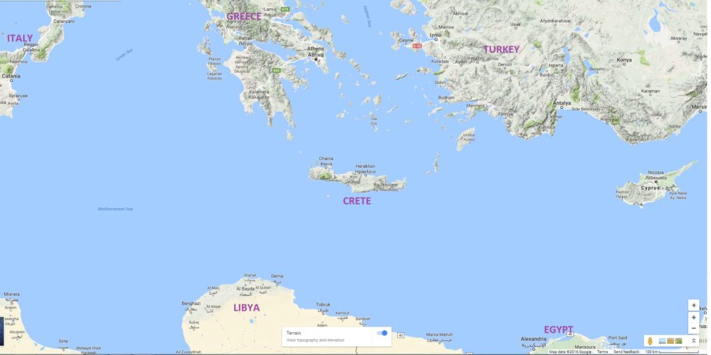
Crete is a long large thin island in the eastern Med some 160 miles north of Libya. It has a spine of mountains running east-west cut by very deep narrow gorges. The summits of the chain are in excess of 2000m (6500 ft) and are snow-covered in winter. east-med

In summer, when the winds are mainly from the north, it is very dry and hot with only teaspoons of rain from May to October . Like most of the Aegean the winds come up to F4 most afternoons (sometimes above) and sweep east along the south coast. However the biggest problem are the winds known locally as katabatics (although I am informed they are a mix of katabatics and foen winds).  When the wind speed in the north is greater than that of the south it rises up the mountains, where it condenses and is compressed in the gorges, accelerating the flow as it comes down the mountains towards the sea.  This can happen very quickly (30 minutes) and produce winds of F8 or more. As a consequence there is virtually no yachting and very little motor boat traffic. The very few kayakers are advised to stay close to shore (the cliffs) and prepare to get off the water very quickly. The support from the hirer includes Text messages to warn if any such winds are possible.

Crete has a long history dating from the earliest European civilisation (the Minoan) over 6000 years ago. The population  is 630,000 and the economy is based on agriculture and tourism with over 2m tourists visiting in any year. Unemployment is currently 30%. For the vast majority of tourists the clean sandy beaches are the main attraction with mandatory visits to the relics of 6000 years of “civilisation”.  Along the coast there are dozens of “taverna” which are particularly attractive in the heat of the afternoon. Greece has an Open Access policy which includes wild camping even on beaches between dusk and dawn.

Apart from ubiquitous goats,  we saw very little wildlife, which is probably due to the absence of rain during the summer. Midges, mosquitoes, flies and other insects were simply (and thankfully) absent. A swallow type of bird lived in the many caves and we saw large raptors (eagles or vultures) over the mountains. We saw no fish or other sea life apart from tiny whitebait skipping across the surface. This appears to be confirmed by the lack of fishing vessels.

The Route

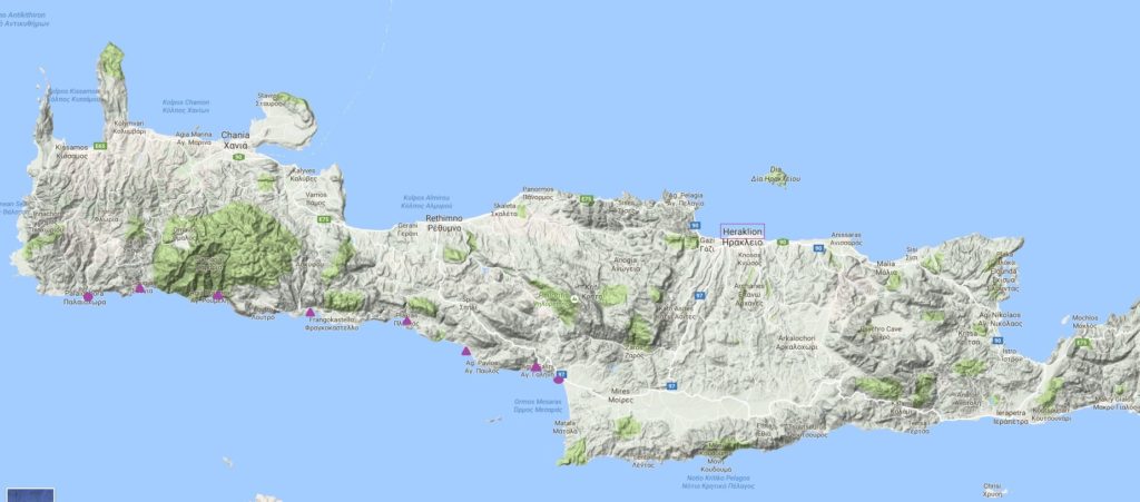
Stelios, who runs the company Enjoy Crete (www.enjoy-crete.com) offers day and multi-day guided tours, which include an 8 day trip along the South coast. If you have proven experience and skills he will also rent kayaks to individual groups for self guided tours. We opted for the 8 day tour (self guided) with the hope of a relatively easy 6 days and the expectation of at least one day trapped by wind.crete-map

This started in a village known as Palaiochora and finished in the village of Kokkinos Pirgos, at the head of a wide broad valley that heads due east and is the centre of Cretan agriculture. Each easy stage was characterised by spectacular scenery, beautiful beaches and excellent taverns. It is impossible to get lost!

Days 1 and 2: Glasgow-Heraklion-Sougea

We caught an afternoon plane for the 4.25 hour flight direct from Glasgow to Heraklion. The time difference is 2 hours so we arrived just after 9pm and got to our hotel in central Heraklion by taxi before 10pm. Heraklion, like all the Cretan towns we saw, is a jumble of squat white blocks, wires and vehicles.

crete-001
From the hotel balcony

The pedestrianized areas in the centre have a range of restaurants and cafes which provided good food at cheap prices.

In the morning at 9.15am we took another taxi to a car park on the sea front where we met Stelios with car and trailer for the long 4 hour journey to the start point at Paliosgora. The wind was blowing F4 plus from the west a couple of km offshore. After purchasing fresh supplies for the next few days (bread, milk, cheese, fruit, gas and, above all else water) and loading the boats we said goodbye to Stelios and at 3.30pm started the journey.

1-crete-008
Departure

This first section was one of the best. The wind had died slightly but there was a big swell and we were pushed along quickly.
1-crete-010

1-pa050003

Sougea Beach
Sougia Beach
1-crete-012
Night at Sougea

Our destination was a village called Sougia. Spread along the beach were a large number of tents (big and small), camper vans, caravans, hammocks and stretched tarpaulins. In addition most of the tourists, mainly from northern Europe particularly Germany, preferred not to wear clothes. Sougia appears to be a left-over from the hippie days of the seventies.

In the village there are good shops and taverns where we spent an enjoyable evening.

Day 3: Sougia-Agia Roumelli

The previous afternoon’s paddle had identified a few equipment problems. Hugh had problems with a buckled back rest which was fixed to the back of the seat and could not be moved, causing quite substantial bruising in the lower back. Ken’s spraydeck fitted the cockpit perfectly but was too small over the deck area which resulted in no body sleeve. This led to water simply running to the waist and pouring into the boat via the trousers. We spent the best part of an hour trying to remedy this by shifting the seat forward  which made it tolerable but far from perfect. Despite attempts to straighten the back rest it immediately folded down on use. Because of these ad hoc repairs we did not leave until after 10am, the latest of any day.

The onward journey was the perfect mix of tiny buildings, sandy beaches, tall cliffs and sun.

1-crete-017
Small Church and Goats

1-crete-0181-crete-022Our initial target was the entrance to the Samaria Gorge at Agia Roumelli. This  gorge is world famous and the centre of Crete’s major national park. Hundreds of people are bussed to the top, walk down the gorge and are then taken by boat back to Sougia where the coach meets them.

Ayia Roumelli
Ayia Roumelli

At the village as we walked up towards the steepest and narrowest section the wind started to become noticeable and by the time we returned at around 4pm was reaching F5 with stronger gusts. It was clearly impossible to move on so we retired to the tavern. At just after 6pm the wind dropped but it was now too late to move so we practiced erecting lightweight tents on a sandy beach in a F4. The food and drink in the adjacent taverna  was excellent.

1-crete-029

Day 4 Agia Roumeli-Hora Skafion

We made an early (8.30) start to another sparkling day.

Depart from Roumelli

1-crete-037-001

For the next couple of days the edge of the sea became interesting. There were rock gardens and caves as well as intricately twisted cliffs interspersed by sandy beaches and a couple of lovely resorts.

1-crete-076pa1000421-crete-0901-crete-043pa100050

1-crete-041
The village of Lautro

A feature of the Med coastline/beaches is steepness and dumping surf. The usual attempt to ride the biggest wave to get as high up the beach as possible can result in the kayak nose diving the beach and broaching. In addition attempted landings were often in front of sunbathers enjoying the spectacle. Although we had no capsizes we rarely got in without a soaking of some sort.

By now another major problem had developed in Hugh’s boat. Despite only being a couple of years old, the boat was taking in water into the rear hatch through the skeg box . A whole day resulted in around 6 litres of water. As last year no direct solution could be found and the whole box had to be taped up. To avoid damaging the tape the boat had to be lifted in and out of the water and even then over time the tape started to peel. Of course the skeg could no longer be used.

After a prolonged lunch break we eventually camped on a small isolated beach just after the village of Hora Sfakion. Behind the beach were high, steep, unstable cliffs. Our worries were not helped by a couple of goats who strayed onto the cliff at the very top, showering us with loose stones. At this site we made our only camp fire. These are banned from most areas and there is very little wood on the beaches so it proved very welcome. The sea crashed on the beach with some ferocity all night.

1-crete-0501-crete-051

Day 5/6 Hora Skafion – Plakias-Agia Fortini

The area around the village of Frangokastello had been identified as potentially the most dangerous. Katabatic winds sweep down from the mountains and a large are adjacent to the shore was shallow and covered with jaggy rocks. The swell is ever-present. We had decided to cross this area early in the morning when winds are lightest and did so with minimum problems.

Francokastello
Francokastello

The castle was built in 1371 by the Venetians who ruled Crete from 1212 to 1669 after the fall of Byzantium. The Ottoman Turks then held Crete through a succession of revolts until 1898. Whilst Orthodox Christianity was always the majority religion, over this period there was a growth in Islam that eventually applied to as much as 45% of the population. The hostility between Greeks and Muslims (aka Turks)  eventually led to the expulsion of the Turks from Crete paralleled by the expulsion of the Greeks from Turkey. This hostility still exists even amongst the young and educated.

A gentle paddle with an extended lunch break eventually took us to Plakias, a thriving resort town where we restocked and then pushed on to the end of the beach.Ken has a swim!!

The morning of day 6 took us around the headland into Damnoni and the Hapimag Beach resort for coffee. If you are going for a beach holiday it is difficult to imagine a nicer place with a lovely beach, water sports and a beautiful (and empty) swimming pool.

The next stop was at a lovely beach called Preveli. This is one of the very few places with a river and, as a result hosts a palm forest in the deep gorge formed by the river.

The palm forest at Preveli

A walk up the gorge, a few cans of beers and we were off again getting increasingly close to our final destination at the village of Agia Fortini.

1-crete-085
The small beach at Agia Fortini


1-crete-084

Day 7   Agia Fortini- Agia Pavlos- Agia Georgas-Agia Galini

From Agia Fortini we headed on to a lovely beach resort at Agia Pavlos (aka Meltemi) for a prolonged coffee break and then on to Agia Georgas for lunch.  The pub served good food and excellent beer  to the sound of good sixties/seventies pop.We had got into the habit of a relatively early start, an extended lunch break and a shortish paddle in the late afternoon and headed on to the next village at Agia Galini in very good spirits.

The quality of the landscape, both land and marine, surprised us. It was truly wonderful with some awesome caves.

Depart from Ayia Georgas
Depart from Agia Fortini

1-crete-095

1-crete-098
A deep Cave
pa070022
Another Cave

1-crete-103

The evening camp at the end of day 7 was at the far end of the beach at Agia Galini, an important tourist resort. The evening meal was the last of those carried from Scotland.

Day 8

The paddle along the coast to Kokkinos Pirgos was only 4km and took less than an hour. We had expected strong easterlies in our face but these failed to materialise and instead we had almost a full day on the beach, swimming, eating and drinking. 1-crete-102At 3.30pm Stelios turned up half an hour early and we packed the car and trailer and were away soon after 4, arriving at the airport at around 6.30 for a 10.30 flight. As might be expected with hours in hand we shot through check-in and security. The plane was early on departure and early on arrival. Baggage handling and passport control caused no delay and we were back in Helensburgh just after 2am.

Concluding Thoughts

This was a wonderful trip with no problems in terms of times, distances and weather. There were equipment failures but we managed to overcome these, albeit with inconvenience. We spent a lot of time in bars and restaurants and these helped make the trip very enjoyable. An accommodation based trip is more than feasible, indeed it is an attractive alternative. The total cost  was £850 (for everything from taxis to ice creams); about £100 more than our trips to Turkey. We would thoroughly recommend Crete as a destination.

Jura 23rd to 28th July 2016

Paddlers: Hugh, Sue, David, Robert, Ken and Geoff

Route: IMG_0103

Report

Jura is a wet, windy, midgey lump of granite and peat bog and offers some of the best sea kayaking in Scotland. As those who have attended Hugh’s Sea Exped course will know, to the north is the dreaded Corryvechan whirlpool, to the south the tide races up and down the Sound of Islay, to the east is the fast running Sound of Jura and to the west an unforgiving coast exposed to Atlantic swells and high winds. Circumnavigation, our original plan, therefore needs excellent, calm, stable weather. Sadly it was wet and windy, Corryvechan looked to be too dangerous and we had to retrace our steps. The following describes our journey and hopefully generates both interest in doing the circumnavigation and some useful information if trying it.

Day 1: Saturday  A major consideration was getting on a south going tide (and the north current up the Sound of Islay after low water). The choice appeared to be a very early start from Helensburgh or an evening drive and an early start the following morning.  With a strong wind from the SE forecast for Saturday we opted for the evening drive. The three of us who ate in the Tayvallich Inn would strongly recommend the food. The chosen departure point was Keilmore jetty (on the Sound) but there was no available parking for 1 car let alone 3, so we came back to Loch na Cille where there is a launch point and some adjacent rough camping. The rain rained and the midges swelled their stomachs. The agreed departure time was 08:00.

Camp 1
Camp 1: Loch na Cille

Day 2: Sunday

At 7.15 Hugh and Ken arrived from their superior site just up the road and by 8am we were away into a  foggy but wonderful peaceful and calm environment.

Arduanie 006
A misty morn
011
Peace
jura 012
Heading South

We headed almost due west across the Sound being gradually taken south by the tide.

After 3hours we took our first break on Jura, some 20km from our start point. There was an unusual urgency about the trip because of the need to make the tides. In the next period we wanted to be at the islands at the mouth of the Islay Sound by 2pm so we pressed on past Craighouse to the boathouse at Ardfin where there is a small beach just to the west of the jetty and, importantly, a picnic table.

The Boathouse at Ardfin

Jura is a very strange place with a total population of 196 for an island of 367sqkm, the lowest population density in Scotland. For comparison Lewis has a population density 20 times that of Jura. On this remote place an Australian financier is building an 18 hole golf course for “his friends” which stretches down to Ardfin. At the boat house in 1992 the “acid house” pop band KLF burnt £1m in notes as a cultural/artistic gesture. More stupid than £2m a golf course?

From Ardfin we were helped up the Sound by the tide passing Port Askaig (and its tiny Jura counterpart) Feolin, stopping for a further break at Bunnabhain.P7240047

Seals
Seals
Passing Port Askaig and the Lagavulin distillery

From here it was another 18km heading west into a strengthening wind and then north west. The cliff scenery was excellent but the wind and intermittent rain made for a tough few hours.P7240050057jura 016

We finally arrived at our target, an excellent beach at the end of Glen Battrick at the mouth of Loch Tarbet. We were all surprised to find in this very, very remote spot (18km by hill track from the nearest single track road and 21km from Port Askaig) a family holiday home, with putting green and some rough cut fairways and greens. We sought permission from the cook/housekeeper to camp on the mowed green area adjacent to the sea and quickly settled down to a meal and bed. Like all of Jura there was no wood for a fire, rain and 10 million midges for company. A rather grim end to a tiring day (60km in under 12 hours). {Note: It appears that the family due was that of David Cameron. Samantha’s stepfather, Viscount Astor (or to be precise an offshore trust based in the Bahamas) owns this part of Jura. There is a video of Cameron taken at the cottage at http://www.bbc.co.uk/news/uk-scotland-23754357 which gives views of the surroundings, house and camp site }.

Arriving
Arriving
camp site 2
camp site 2

Day 3 Monday

As forecast  a brisk F4/5 wind from the west was blowing and it was decided to explore Loch Tarbet. This is a huge sea loch that nearly bisects Jura and effectively has 3 parts. The outer and middle are joined by a wind exposed channel that was “lumpy” as the strong westerly hit the outgoing tide. Inevitably the photographic record does not include the roughest passages.loch tarbert

The inner is reached by a thin passage between cliffs; a quite extraordinary feature. Inside the wind was less of a problem. At the far side of the inner loch a good track runs to the road providing, we were glad to note, an escape from the hostile west coast.

094

After a luch in the inner loch we headed back out and tracked across to the MBA bothy Cruib Lodge.

Cruib Lodge
Cruib Lodge

From Cruib we battled in to the wind back through the narrows and the outer loch to an excellent beach and camp site near a ruined farm called Ruantalain. The wildlife consisted of 5 Black Goats and 20 million midges. What do midges live on when humans are not around?110124

Looking across to Camp 2

P7250058

P7250057

Despite a massive search for driftwood none was found. Where does it go on Jura? And so to bed.

Day4 Tuesday

A major problem always faced is when to turn back. Corryvechan is safe in calm conditions for about 1 hour at Neeps. In an F5 or outside the slack it is dangerous. There is usually a period of light wind in any system (e.g. in the early morning) but it has to coincide with the slack water. The forecast was continuing north westerleys F4/5 eventually switching to north easterlies. It seemed likely that if we had carried on in fairly rough water, we still could not have gone through and quite possibly have been stuck for  2 or 3 days or even more. So it was decided, with some regret, to retreat.  The paddle back was windy but we caught the tide in the Sound and were back at Ardfin for a late lunch.138

156DSCN0843

From Ardfin the travel north was both windy and very wet and the stop at Craighouse very welcome.

188

jura 048
Camp site 4 (&5)

The campsite at Criaghouse is adjacent to the shore, perfectly green and flat, well sheltered and has excellent showers and a large dryer. It is adjacent to the pub (where you pay and get the shower block key) and at £5 per tent it is excellent value. A shower, good meal, dry clothes and a beer then bed.

Day 5 Wednesday 

The tide north finished at 11 and did not restart until 5. If we were to get back we needed to either leave early or at the latest 5pm (unless we wanted to paddle at night). Sadly a strengthening wind made both impossible and so we spent a pleasant day waiting for the wind to drop and debating about when to go and what to do if the strong winds did not ease. For reference the eventual escape route plan involved the drivers going on the afternoon Craighouse-Tayvallich Rib service and a taxi back to Loch na Ciche whilst the others got a trailer down to Feolin with the kayaks and carried them on to the Feolin (Jura) and afternoon Kennacraig (Islay) ferries. The drivers would then drive round to Kennacraig.

DSCN0851
Waiting


Thankfully by the late evening the wind had eased and an early morning (6am) departure was agreed before the winds got up again and the tides turned.

Day 6 Thursday

5am in Craighouse was flat calm and grey. With relief we managed to be packed up and ready to go by 6am, just as the only sun of the day broke through the clouds.DSCN0858P7280063267

We paddled north and after a short break after 2 hours crossed the Sound. As on most of the trip we were often accompanied by seals, both grey and common.

DSCN0846

The crossing was uneventful, the only slight difficulty being locating the entrance to Loch na Cille.

P7260062

By 10 am we were back on shore having had an excellent few days.

jura 055


Lessons and personnel

The key lesson? Do the most difficult, weather dependent section (in this case the Corryvechan) as soon as possible when the forecasts are most reliable. It is still not clear when we could have got through safely given the wind changes. The second lesson is that even in adverse conditions, sea kayaking is wonderful.

This last section is simply to provide space for photos of colleagues taken on the trip


jura 043jura 015jura 042jura 040149P7240040


Arduanie, Shuna, Torsa, and Seil

Paddlers: Geoff, Hugh, Vee, Robert

Weather: Dreadful. Wind from SW F4 moderating to strong F3. Continuous Rain. Poor visibility

Route:  arduanie

Report: This is a great kayaking area and it is a delight to report that the new carpark and canoe slip at Arduanie are first class. However the weather forecast was dreadful and it did not lie. It rained almost continually, sometimes moderate and sometimes heavy, until we completed the trip at around 17.30. The wind was always present and the return was a slog. These next two photos illustrate the views of the  landscape:

Arduanie 006

Arduanie 002

The Good Bits? The company, otters, geese, birdlife in general, playing in the channel between Luing and Torsa and finding the beached/wrecked boat at the end of Shuna.

Arduanie 005

A reasonable list long enough to suggest a day well spent.